
Dingle Peninsula


The Dingle Peninsula (Irish: Corca Dhuibhne - anglicized as Corkaguiny, the name of the corresponding barony) is the northernmost of the major peninsulae in County Kerry. Its ends beyond the town of Dingle at Dunmore Head, the westernmost point of Ireland.
Name
The Dingle Peninsula is named after the town of Dingle. The peninsula is also commonly called Corca Dhuibhne (Corcu Duibne) even when those referring to it are speaking in English. Corca Dhuibhne,[1] which means "seed or tribe of Duibhne"[2] (an Irish personal name), takes its name from the túath (people, nation) of Corco Dhuibhne who occupied the peninsula in the Middle Ages and who also held a number of territories in the south and east of County Kerry.
Geography
The peninsula exists because of the band of sandstone rock that forms the Slieve Mish mountain range at the neck of the peninsula, in the east, and the unnamed central mountain range further to the west. Ireland's highest mountain outside Macgillycuddy's Reeks, Mount Brandon at 951 m, forms part of a beautiful high ridge with stunning views over the peninsula and North Kerry.
The Conor Pass, which runs from Dingle on the southern end of the peninsula towards Brandon Bay and Castlegregory in the North, is the highest mountain pass in Ireland[citation needed], a tight, precarious road, weaving its way around the sharp cliff faces and past the high corrie lakes.
The Blasket Islands lie off the west coast. They are famous for the literary and linguistic heritage of the former inhabitants. However, these remote islands have been uninhabited since the 1950s following an evacuation.
Culture and language
The western end of the peninsula is a Gaeltacht (Irish-speaking area) that has produced a number of nationally notable authors and poets; Ó Siochfhradha and Peig Sayers among others. This is the most western part of Ireland, and the village of Dún Chaoin is often jokingly referred to as "the next parish to America"
Archaeology
The peninsula is the location of numerous prehistoric and early medieval remains including:
- Ferriter's Cove, at the western tip of the peninsula; and
- Gallarus Oratory in the very west of the peninsula near the village of Baile an Fheirtéaraigh in Ard na Caithne.
Músaem Chorca Dhuibhne, situated in the village of Baile an Fheirtéaraigh (Ballyferriter) has exhibitions detailing the archaeology and history of the peninsula. Some of the exhibitions include Ogham stones, artifacts from the excavations at the nearby monastic site of Riasc (Reask) and objects on loan from the National Museum of Ireland.[3]
In film
David Lean's 1970 film Ryan's Daughter takes place at a village on the Dingle Peninsula in the immediate aftermath of the 1916 Easter Rising, and was partly shot on location near Dún Chaoin, Coumeenole Beach, Slea Head and Inch Strand.[4] Far and Away, a 1992 film directed by Ron Howard, was partly filmed on the peninsula.[5]
The film Leap Year is partly set in the Dingle Peninsula, but none of the filming took place in the area.[6]
Gallery

-
 Dingle Peninsula as viewed from Banna Strand
 -
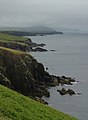 Dingle Peninsula coastline
 -
 Minard Castle, Lispole, County Kerry
 -
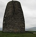 Eask Tower with view of the tip of the Ring of Kerry in foreground.
 -
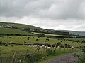 The fauna of Dingle Peninsula
 -
 The Ranga was wrecked near Coumeenole Beach in 1982. The remains are still visible today.


See also
- Beara Peninsula
- Eask tower
- Iveragh Peninsula
- Mount Brandon
- Munster Irish
- MV Ranga, a ship wrecked near Coumeenole Beach, near Slea Head, Dingle
References
- ^ Suzanne Barrett's Ireland for Visitors, April 2009
- ^ Ireland's Dingle Peninsula Tourism, April 2009
- ^ "Músaem Chorca Dhuibhne: Exhibitions". Músaem Chorca Dhuibhne. Retrieved 7 April 2011.
- ^ "Ryan's Daughter (1970): Locations". IMDB. Retrieved 31 May 2011.
- ^ "Far and Away (1992): Locations". IMDB. Retrieved 31 May 2011.
- ^ "Leap Year (2010/1): Locations". IMDB. Retrieved 31 May 2011.