
Dorado barrio-pueblo
Dorado barrio-pueblo
Pueblo de Dorado | |
|---|---|
Municipality Seat | |
 Town Hall in Dorado barrio-pueblo | |
 Location of Dorado barrio-pueblo within the municipality of Dorado shown in red | |
 Dorado barrio-pueblo | |
| Coordinates: 18°27′34″N 66°15′41″W / 18.459338°N 66.261445°W[1] | |
| Commonwealth | |
| Municipality | |
| Area | |
| • Total | 0.07 sq mi (0.2 km2) |
| • Land | 0.07 sq mi (0.2 km2) |
| • Water | 0 sq mi (0 km2) |
| Elevation | 52 ft (16 m) |
| Population (2010) | |
| • Total | 780 |
| • Density | 11,142.9/sq mi (4,302.3/km2) |
| Source: 2000 Census | |
| ZIP Code | 00646 |
Dorado barrio-pueblo is a barrio and the administrative center (seat) of Dorado, a municipality of Puerto Rico. Its population in 2010 was 780.[3][4][5][6] It is one of the 6 barrios in the municipality of Dorado, Puerto Rico, along with Espinosa, Higuillar, Maguayo, Mameyal and Río Lajas.[7]
As was customary in Spain, in Puerto Rico, the municipality has a barrio called pueblo which contains a central plaza, the municipal buildings (city hall), and a Catholic church. Fiestas patronales (patron saint festivals) are held in the central plaza every year.[8][9]
| Census | Pop. | Note | %± |
|---|---|---|---|
| 1900 | 937 | — | |
| 1910 | 946 | 1.0% | |
| 1920 | 1,163 | 22.9% | |
| 1930 | 2,053 | 76.5% | |
| 1940 | 2,211 | 7.7% | |
| 1950 | 2,537 | 14.7% | |
| 1980 | 1,347 | — | |
| 1990 | 1,081 | −19.7% | |
| 2000 | 994 | −8.0% | |
| 2010 | 780 | −21.5% | |
| U.S. Decennial Census[10] 1899 (shown as 1900)[11] 1910-1930[12] 1930-1950[13] 1980-2000[14] 2010[15] | |||
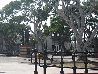
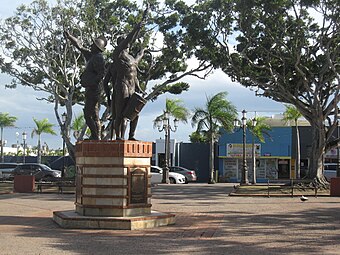
The central plaza and its church
The central plaza, or square, is a place for official and unofficial recreational events and a place where people can gather and socialize from dusk to dawn. The Laws of the Indies, Spanish law, which regulated life in Puerto Rico in the early 19th century, stated the plaza's purpose was for "the parties" (celebrations, festivities) (Spanish: a propósito para las fiestas), and that the square should be proportionally large enough for the number of neighbors (Spanish: grandeza proporcionada al número de vecinos). These Spanish regulations also stated that the streets nearby should be comfortable portals for passersby, protecting them from the elements: sun and rain.[8]
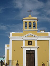
Located across the central plaza in Dorado barrio-pueblo is the Parroquia San Antonio de Padua (English:The San Antonio de Padua Catholic Church), named after Portuguese Catholic priest Saint Anthony of Padua. The church was built from 1826 throughout July 1848.[17]
History
Puerto Rico was ceded by Spain in the aftermath of the Spanish–American War under the terms of the Treaty of Paris of 1898 and became an unincorporated territory of the United States. In 1899, the United States Department of War conducted a census of Puerto Rico finding that the population of Dorado Pueblo was 937.[18]
In July 2020, Federal Emergency Management Agency appropriated funds for repairs to Dorado's plaza.[19]
Sectors
Barrios (which are roughly comparable to minor civil divisions)[6] in turn are further subdivided into smaller local populated place areas/units called sectores (sectors in English). The types of sectores may vary, from normally sector to urbanización to reparto to barriada to residencial, among others.[20][21][22]
The following sectors are in Dorado barrio-pueblo:[23]
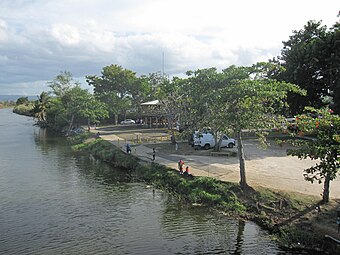
Barriada San Antonio, Residencial Manuel Morales, Sector Finca Santa Bárbara, Sector Juan Francisco, Sector La Julia, Sector Mameyal Playa (stretch of PR-165), Urbanización Brisas de Plata (before Villa Caíto), Urbanización Jardines de Dorado, Urbanización Martorell, and Urbanización Sabanera Dorado.
In Dorado barrio-pueblo is part of the Dorado urban zone.
Gallery
Places in Dorado barrio-pueblo:
-
 Plaza
Plaza -
 Plaza
Plaza -
-
 San Antonio de Padua Catholic church


See also
References
- ^ a b "US Gazetteer 2019". US Census. US Government.
- ^ U.S. Geological Survey Geographic Names Information System: Dorado barrio-pueblo
- ^ Puerto Rico:2010:population and housing unit counts.pdf (PDF). U.S. Dept. of Commerce, Economics and Statistics Administration, U.S. Census Bureau. 2010.
- ^ Picó, Rafael; Buitrago de Santiago, Zayda; Berrios, Hector H. Nueva geografía de Puerto Rico: física, económica, y social, por Rafael Picó. Con la colaboración de Zayda Buitrago de Santiago y Héctor H. Berrios. San Juan Editorial Universitaria, Universidad de Puerto Rico,1969.
- ^ Gwillim Law (20 May 2015). Administrative Subdivisions of Countries: A Comprehensive World Reference, 1900 through 1998. McFarland. p. 300. ISBN 978-1-4766-0447-3. Retrieved 25 December 2018.
- ^ a b "US Census Barrio-Pueblo definition". factfinder.com. US Census. Archived from the original on 13 May 2017. Retrieved 5 January 2019.
- ^ Puerto Rico 2000: Population and Housing Unit Counts
- ^ a b Santullano, Luis A. (10 March 2019). Mirada al Caribe. Vol. 54. Colegio de Mexico. pp. 75–78. doi:10.2307/j.ctvbcd2vs.12. JSTOR j.ctvbcd2vs.12.
- ^ Pariser, Harry S. (2003). Explore Puerto Rico, Fifth Edition. San Francisco: Manatee Press. pp. 52–55. Retrieved 10 February 2019.
- ^ "U.S. Decennial Census". United States Census Bureau. Archived from the original on February 13, 2020. Retrieved September 21, 2017.
- ^ "Report of the Census of Porto Rico 1899". War Department Office Director Census of Porto Rico. Archived from the original on July 16, 2017. Retrieved September 21, 2017.
- ^ "Table 3-Population of Municipalities: 1930 1920 and 1910" (PDF). United States Census Bureau. Archived (PDF) from the original on August 17, 2017. Retrieved September 21, 2017.
- ^ "Table 4-Area and Population of Municipalities Urban and Rural: 1930 to 1950" (PDF). United States Census Bureau. Archived (PDF) from the original on August 30, 2015. Retrieved September 21, 2014.
- ^ "Table 2 Population and Housing Units: 1960 to 2000" (PDF). United States Census Bureau. Archived (PDF) from the original on July 24, 2017. Retrieved September 21, 2017.
- ^ Puerto Rico:2010:population and housing unit counts.pdf (PDF). U.S. Dept. of Commerce Economics and Statistics Administration U.S. Census Bureau. 2010. Archived (PDF) from the original on 2017-02-20. Retrieved 2019-08-02.
- ^ "Population and Housing Unit Estimates". United States Census Bureau. Retrieved September 21, 2017.
- ^ Mari Mut, José A. (2013-08-28). Los Pueblos de Puerto Rico y Las Iglesias de Sus Plazas [The Pueblos of Puerto Rico, and the Churches of its Plazas] (PDF) (in Spanish). pp. 85–87. Archived (PDF) from the original on 2020-12-14. Retrieved 2021-08-15.
- ^ Joseph Prentiss Sanger; Henry Gannett; Walter Francis Willcox (1900). Informe sobre el censo de Puerto Rico, 1899, United States. War Dept. Porto Rico Census Office (in Spanish). Imprenta del gobierno. p. 161.
- ^ "FEMA Approves Funds to Repair PR Town Squares". Hudson Valley Press. 2020-07-08. Retrieved 2021-09-23.
- ^ "Agencia: Oficina del Coordinador General para el Financiamiento Socioeconómico y la Autogestión (Proposed 2016 Budget)". Puerto Rico Budgets (in Spanish). Retrieved 28 June 2019.
- ^ Rivera Quintero, Marcia (2014), El vuelo de la esperanza: Proyecto de las Comunidades Especiales Puerto Rico, 1997-2004 (first ed.), San Juan, Puerto Rico Fundación Sila M. Calderón, ISBN 978-0-9820806-1-0
- ^ "Leyes del 2001". Lex Juris Puerto Rico (in Spanish). Retrieved 24 June 2020.
- ^ "PRECINTO ELECTORAL DORADO 015" (PDF). Comisión Estatal de Elecciones (in Spanish). PR Government. Archived (PDF) from the original on 9 November 2016. Retrieved 4 May 2020.