
Ein Avdat
Ein Avdat (Hebrew: עין עבדת) or Ein Ovdat is a canyon in the Negev Desert of Israel, south of the kibbutz Sde Boker. It has always been an attractive place for habitation due to its luxuriant fauna and flora in the middle of the desert. Consequently, the canyon and its surroundings have been inhabited for some 80,000–90,000 years by many peoples such as Neanderthals, Nabateans, and Christian monks. The canyon also attracts numerous species of animals, like Ibexes and various birds, to its fertile vegetation.
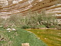
The flourishing environment is caused by the water of numerous springs that begins at the southern opening of the canyon, and descends into deep pools in series of waterfalls. The springs in Ein Avdat emerge from between layers of rocks, although the source is still not known definitely. Around the springs grows salt-loving plants like Poplar trees and Atriplexes.
Etymology
Ein (Hebrew: עין) is the Hebrew word for spring or water source, referring to the various springs located in the canyon, while the word Avdat (Hebrew: עבדת) derives from the neighbouring city of Avdat situated south of the canyon.[1] The city of Avdat is named after the Nabataean King Obodas I that according to tradition was buried there. His name was then arabized to Abdah (Arabic: عبدا) and finally hebraicized to Avdat. Thus Ein Avdat is the Spring of Obodas.[2]
History
Prehistoric era
During the prehistoric era, Ein Avdat and its surroundings were for thousands of years inhabited, implied by the numerous flint artefacts that have been found in the area. The tools belonged to the Neanderthalic Mousterian culture which was active in the area 80,000–90,000 years ago. The abundance of flint in the outcrops nearby were apparently utilized by Neanderthals for many types of tools such as arrows, points and others. The ostrich egg shells and onager bones that have been found helps to describe the fauna of the epoch.
In the area there is also a large concentration of flint tool remnants, samples of man-made knives and other hand held stones that is dating from the Paleolithic and Mesolithic periods, and remains of a small settlement consisting of several round structures dating from the Bronze Age.[3]
Antiquity

During the Hellenistic period the nearby city of Avdat became a station along the Nabatean Incense Route, an ancient trading route stretching across Egypt to India through the Arabian Peninsula. Other regions in the Negev were not inhabited and there was no agriculture at the time. However, agriculture developed during the early Roman era when the Nabataean kingdom peaked. At this time the forts of the Incense Route became thriving cities with many public buildings along with farming at the outskirts, and although the kingdom was annexed by the Roman empire in 106 CE, Avdat continued to prosper as a major station along the Incense Route.[3][4]
The city developed into a Christian city during the Byzantine period and Ein Avdat became inhabited by monks who lived in the caves of the canyon. These monks sculpted out closets, shelves, benches, stairs, and water systems. The caves are also decorated with crosses and prayers engraved on the walls.[3][5] After the Muslim conquest of Palestine though the region was abandoned.[3]
Modern era
The place became easily accessible in the 1950s, after the establishment of the kibbutz Sde Boker in 1952, and the construction of Highway 40 leading to Eilat. The trail going through the canyon was constructed in 1956 and is now a part of the Israel National Trail, a hiking path that crosses the entire country of Israel.[3]
Because of its rich milieu and history Ein Avdat has been designated as a National Park of Israel. The Ein Avdat national park (Hebrew: גנים לאומיים עין עבדת) incorporates the canyon for all its length. There are two entrances, a southern at the summit of the canyon, located at roughly Template:M to ft above sea level, and a northern at approximately Template:M to ft above sea level. Between them there is a distance of Template:Km to mi.[6][7]
Geography
| Ein Avdat | ||||||||||||||||||||||||||||||||||||||||||||||||||||||||||||
|---|---|---|---|---|---|---|---|---|---|---|---|---|---|---|---|---|---|---|---|---|---|---|---|---|---|---|---|---|---|---|---|---|---|---|---|---|---|---|---|---|---|---|---|---|---|---|---|---|---|---|---|---|---|---|---|---|---|---|---|---|
| Climate chart (explanation) | ||||||||||||||||||||||||||||||||||||||||||||||||||||||||||||
| ||||||||||||||||||||||||||||||||||||||||||||||||||||||||||||
| ||||||||||||||||||||||||||||||||||||||||||||||||||||||||||||
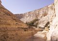
The canyon of Ein Avdat is part of Nahal Zin, the largest Wadi or dry riverbed in the Negev. The 120 kilometre long Nahal Zin begins along the northwestern part of Makhtesh Ramon and heads north. Ein Avdat marks an abrupt change in Nahal Zin's route as it leads the wadi eastwards. Nahal Zin, including Ein Avdat, was created by erosion as the great height difference caused flowing water to carve canyons along its way. Some prehistoric objects that have been found suggests that Ein Avdat was formed only 80,000 years ago.[3][5]
Springs
The initial and southernmost spring in the canyon is Ein Ma'arif.[3][8] It forms a chain of waterfalls and pools with one waterfall being Template:M to ft high.[9] Nearby there are remains of a Byzantine fortress which controlled the descent to the spring and the agricultural land of the surroundings.[5][9]
Further north of Ein Ma'arif there is a 15 meter high waterfall that descends into a 8 meter deep pool of water that is divided into two parts by a small artificial dam. Recently it has been forbidden to swim in the pool, as well as drinking from it, in order to avoid disturbing the animals that lives there. The spring is called Ein Avdat and should not be confused with the canyon itself.[3][8][10][11]
Located near the northern entrance of the national park there is a spring called Ein Mor. Ein mor, the lowest spring in the canyon, was named after the spice of Myrrh, Mor (Hebrew: מור) being Hebrew for myrrh. The neighbouring city of Avdat saw the travels of many camels carrying myrrh northward, due to the city being part of the ancient Incence Route, and thus giving the spring its name.[8][12]
The springs in Ein Avdat emerge from between horizontal layers of rocks, although the source of the water is still not known definitely. The current theory is that the springs come from flash flood water that has seeped down through the stream's bed gravel.[3]
Fauna and Flora

Due its lush vegetation, the area of the springs attracts large numbers of animals such as insects like the dragonfly, songbirds such as the Bulbul, rock pigeons, birds of prey, frogs and ibexes. The canyon cliffs are sometimes used by eagles as nesting spots. Other birds of prey that also can be seen are vultures, hawks and bustards.
Around the springs there are Poplar trees and Atriplexes, commonly known as saltbush, which usually grows on riverbanks and can tolerate a certain amount of salinity in the ground such as the climate of the springs in the canyon. The salinity as well as the flow of the water varies through the seasons, although the springs are active all year round.[3][6][9][11]
Climate
A weather station at Sde Boker register the climate of the area. The summers are hot with almost no precipitation while the winters are cold with some segments of rain. The lowest temperature that has been recorded was in January at −3.6 °C (25.5 °F), whereas during summers it can reach over 40 °C (104 °F). The humidity of the area is relatively high, during winter it usually is over 75% in the morning and at noon less than 50%, while in the summer at the same time of the day it is around 50% and less than 30% respectively.[13]
Gallery
-
 Ein Avdat
 -
 Ein Avdat Spring
 -
 Another view of Ein Avdat
 -
 Flash flood in Ein Avdat


References
- ^ "The Glossary of Terms and Names". mosaic.lk.net. Retrieved 2009-01-25.
- ^ Jacobs, Daniel (1998). "Dimona and Mamshit". Israel and the Palestinian Territories: The Rough Guide. Rough Guides. p. 531. ISBN 1858282489. Retrieved 2009-01-13.
{{cite book}}: Unknown parameter|coauthors=ignored (|author=suggested) (help) - ^ a b c d e f g h i j "Ein Avdat". mosaic.lk.net. Retrieved 2009-01-16.
- ^ "Ein Avdat". Jewish Virtual Library. Retrieved 2009-01-23.
- ^ a b c "Nahal Zin, Ein Avdat". bibleplaces.com. Retrieved 2009-01-17.
- ^ a b "Ein Avdat National Park". Israel Nature and National Parks Protection Authority. Retrieved 2009-01-17.
- ^ Orgad, Avigdor. "Ein-Avdat National Park". Kalmanovitz Bros. Retrieved 2009-02-06.
{{cite web}}: Unknown parameter|coauthors=ignored (|author=suggested) (help) - ^ a b c "Ein Avdat - A Desert Fresh Water Ecosystem". Caretakers Israel. Retrieved 2009-01-23.
- ^ a b c "Ein Ovdat National Park". boker.org.il. Retrieved 2009-01-23.
- ^ Winter, Dave (1999). Israel Handbook: With the Palestinian Authority Areas (2 ed.). Footprint Travel Guides. p. 841. ISBN 1900949482. Retrieved 2009-02-05.
{{cite book}}: Unknown parameter|coauthors=ignored (|author=suggested) (help) - ^ a b "Ein Avdat, Double waterfall". virtualtourist.com. Retrieved 2009-02-05.
- ^ Strutin, Michal (2001). "Northern Negev". Discovering Natural Israel (illustrated ed.). Jonathan David Company, Inc. p. 341. ISBN 082460413X. Retrieved 2009-01-23.
- ^ "Climate information". The Israel Meteorological Service. Retrieved 2009-02-01.