Elzer Berg
Appearance
You can help expand this article with text translated from the corresponding article in German. (July 2010) Click [show] for important translation instructions.
|
| Elzer Berg | |
|---|---|
 | |
| Highest point | |
| Elevation | 291 m (955 ft) |
| Geography | |
| Location | Hesse, Germany |

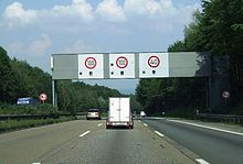
The Elzer Berg is a hill in Hesse, Germany. The Autobahn A3 crosses the hill. Its downhill slope facing Limburg is known for
its speed limit that is rigorously enforced with cameras mounted in the sign gantries.
A tunnel of the high speed train track from Cologne to Frankfurt runs under the hill as well.
50°24′41″N 7°58′23″E / 50.41139°N 7.97306°E
