
File:400 through Parry Sound.png

Size of this preview: 800 × 600 pixels. Other resolutions: 320 × 240 pixels | 640 × 480 pixels | 1,024 × 768 pixels | 1,280 × 960 pixels | 2,560 × 1,920 pixels | 3,264 × 2,448 pixels.
Original file (3,264 × 2,448 pixels, file size: 22.9 MB, MIME type: image/png)
| This is a file from the Wikimedia Commons. Information from its description page there is shown below. Commons is a freely licensed media file repository. You can help. |
Summary
| Description |
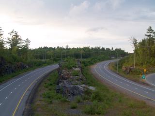
English: Highway 400 facing north from within Parry Sound. This 10 km section of Highway 400 south of and through Parry Sound features interesting and massive rock cuts, some longer than a kilometre in length and several storeys high. This section also features several median rock walls that were left in place during blasting, as in this photo. |
| Date |
|
| Source |
Own work
|
| Author | Uploaded by Floydian at en.wikipedia |
| Camera location | | View this and other nearby images on: OpenStreetMap |
|---|
Licensing
This file is licensed under the Creative Commons Attribution-Share Alike 3.0 Unported license.
- You are free:
- to share – to copy, distribute and transmit the work
- to remix – to adapt the work
- Under the following conditions:
- attribution – You must give appropriate credit, provide a link to the license, and indicate if changes were made. You may do so in any reasonable manner, but not in any way that suggests the licensor endorses you or your use.
- share alike – If you remix, transform, or build upon the material, you must distribute your contributions under the same or compatible license as the original.
Original upload log
The original description page was here. All following user names refer to en.wikipedia.
Upload date | User | Bytes | Dimensions | Comment
- 2011-08-26 20:44 (UTC) | Floydian | 24012115 (bytes) | 3264×2448 | {{Information |Description=Highway 400 facing north from within Parry Sound. This 10 km section of Highway 400 south of and through Parry Sound features interesting and massive rock cuts, some longer than a kilometre in length and several storeys hig
File history
Click on a date/time to view the file as it appeared at that time.
| Date/Time | Thumbnail | Dimensions | User | Comment | |
|---|---|---|---|---|---|
| current | 09:32, 12 December 2011 | | 3,264 × 2,448 (22.9 MB) | SreeBot | (Original text) : {{Information |Description=Highway 400 facing north from within Parry Sound. This 10 km section of Highway 400 south of and through Parry Sound features interesting and massive rock cuts, some longer than a kilometre in length and sever |
File usage
The following pages on the English Wikipedia use this file (pages on other projects are not listed):
Global file usage
The following other wikis use this file:
- Usage on de.wikipedia.org
- Usage on uk.wikipedia.org
- Usage on www.wikidata.org
- Usage on zh.wikipedia.org