
File:A former adit to the North Pit of Cwt y Bugail - geograph.org.uk - 587293.jpg
No higher resolution available.
A_former_adit_to_the_North_Pit_of_Cwt_y_Bugail_-_geograph.org.uk_-_587293.jpg (640 × 480 pixels, file size: 156 KB, MIME type: image/jpeg)
| This is a file from the Wikimedia Commons. Information from its description page there is shown below. Commons is a freely licensed media file repository. You can help. |
Summary
| Description |
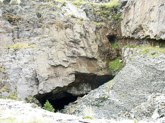
English: A former adit to the North Pit of Cwt y Bugail A tramway linking the North and South Pits followed a narrow carved shelf above the deep hole in the South Pit. This was reinforced by a packwall on the eastern side of the hole. Over time a section near the mouth of the adit has collapsed or possibly been deliberately breached for safety reasons so that it is not possible to walk through to the North Pit at this point. |
| Date | |
| Source | From geograph.org.uk |
| Author | Eric Jones |
| Attribution (required by the license) | Eric Jones / A former adit to the North Pit of Cwt y Bugail / |
| Camera location | | View this and other nearby images on: OpenStreetMap |
|---|
_heading:0.00&language=en)
| Object location | | View this and other nearby images on: OpenStreetMap |
|---|
_heading:0.00&language=en)
Licensing

|
This image was taken from the Geograph project collection. See this photograph's page on the Geograph website for the photographer's contact details. The copyright on this image is owned by Eric Jones and is licensed for reuse under the Creative Commons Attribution-ShareAlike 2.0 license.
|
This file is licensed under the Creative Commons Attribution-Share Alike 2.0 Generic license.
Attribution: Eric Jones
- You are free:
- to share – to copy, distribute and transmit the work
- to remix – to adapt the work
- Under the following conditions:
- attribution – You must give appropriate credit, provide a link to the license, and indicate if changes were made. You may do so in any reasonable manner, but not in any way that suggests the licensor endorses you or your use.
- share alike – If you remix, transform, or build upon the material, you must distribute your contributions under the same or compatible license as the original.
File history
Click on a date/time to view the file as it appeared at that time.
| Date/Time | Thumbnail | Dimensions | User | Comment | |
|---|---|---|---|---|---|
| current | 12:59, 6 February 2011 | | 640 × 480 (156 KB) | GeographBot | == {{int:filedesc}} == {{Information |description={{en|1=A former adit to the North Pit of Cwt y Bugail A tramway linking the North and South Pits followed a narrow carved shelf above the deep hole in the South Pit. This was reinforced by a packwall on th |
File usage
The following pages on the English Wikipedia use this file (pages on other projects are not listed):