
File:Air routes from PVG.png

Size of this preview: 800 × 419 pixels. Other resolutions: 320 × 168 pixels | 640 × 335 pixels | 1,201 × 629 pixels.
Original file (1,201 × 629 pixels, file size: 144 KB, MIME type: image/png)
| This is a file from the Wikimedia Commons. Information from its description page there is shown below. Commons is a freely licensed media file repository. You can help. |
Summary
| Description |
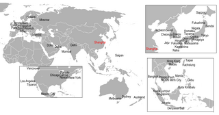
English: Direct international flights with CAN |
| Date | 18 December 2009 (original upload date) |
| Source | Own work |
| Author | ASDFGH |
Licensing
ASDFGH at English Wikipedia, the copyright holder of this work, hereby publishes it under the following license:
This file is licensed under the Creative Commons Attribution 3.0 Unported license.
Attribution: ASDFGH at English Wikipedia
- You are free:
- to share – to copy, distribute and transmit the work
- to remix – to adapt the work
- Under the following conditions:
- attribution – You must give appropriate credit, provide a link to the license, and indicate if changes were made. You may do so in any reasonable manner, but not in any way that suggests the licensor endorses you or your use.
Original upload log
Transferred from en.wikipedia to Commons by Sreejithk2000 using CommonsHelper.
The original description page was here. All following user names refer to en.wikipedia.
- 2009-12-18 05:40 ASDFGH 1201×629× (147387 bytes) {{Information |Description=Direct international flights with CAN |Source={{own}} |Author=[[User:ASDFGH|ASDFGH]] |Date= |Permission= |other_versions= }} [[Category:Maps of cities served by flights from given airport]] == Licensing == {{self|
File history
Click on a date/time to view the file as it appeared at that time.
| Date/Time | Thumbnail | Dimensions | User | Comment | |
|---|---|---|---|---|---|
| current | 07:03, 29 May 2010 | | 1,201 × 629 (144 KB) | File Upload Bot (Magnus Manske) | {{BotMoveToCommons|en.wikipedia|year={{subst:CURRENTYEAR}}|month={{subst:CURRENTMONTHNAME}}|day={{subst:CURRENTDAY}}}} {{Information |Description={{en|Direct international flights with CAN<br/> [[:en:Category:Maps of cities served by flights from given a |
File usage
No pages on the English Wikipedia use this file (pages on other projects are not listed).
Global file usage
The following other wikis use this file:
- Usage on eu.wikipedia.org
- Usage on id.wikipedia.org