
File:Bonne - Carte hydro-geo-graphique des Indes Orientales.jpg

Size of this preview: 800 × 582 pixels. Other resolutions: 320 × 233 pixels | 640 × 465 pixels | 1,024 × 745 pixels | 1,280 × 931 pixels | 2,560 × 1,861 pixels | 10,451 × 7,599 pixels.
Original file (10,451 × 7,599 pixels, file size: 15.59 MB, MIME type: image/jpeg)
| This is a file from the Wikimedia Commons. Information from its description page there is shown below. Commons is a freely licensed media file repository. You can help. |
| Warning | The original file is very high-resolution. It might not load properly or could cause your browser to freeze when opened at full size. |
|---|
Summary
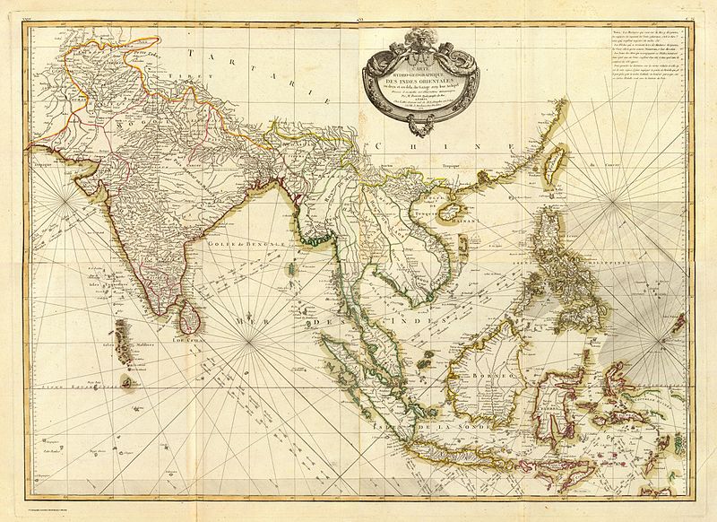
Rigobert Bonne (1727–1795), Carte hydro-geo-graphique des Indes Orientales en deca et au dela du Gange avec leur archipel …, Paris 1771
- Type: Composite Map
- Original: 59 x 81 cm
- Published in: Atlas moderne ou collection de cartes sur toutes les parties du globe terrestre par plusieurs auteurs
- Date: 1791
- Scale: 10,000,000
| Rigobert Bonne
(1727–1794) |
|||
|---|---|---|---|
| Alternative names |
epiphane | ||
| Description | French cartographer | ||
| Date of birth/death |
6 October 1727 | 1795 | |
| Location of birth/death | Raucourt (Ardennes) | Paris | |
| Work location | |||
| Authority file | |||
Licensing
|
This is a faithful photographic reproduction of a two-dimensional, public domain work of art. The work of art itself is in the public domain for the following reason:
The official position taken by the Wikimedia Foundation is that "faithful reproductions of two-dimensional public domain works of art are public domain".
This photographic reproduction is therefore also considered to be in the public domain in the United States. In other jurisdictions, re-use of this content may be restricted; see Reuse of PD-Art photographs for details. | ||||
File history
Click on a date/time to view the file as it appeared at that time.
| Date/Time | Thumbnail | Dimensions | User | Comment | |
|---|---|---|---|---|---|
| current | 22:22, 22 February 2007 | | 10,451 × 7,599 (15.59 MB) | Frank Schulenburg | Rigobert Bonne (1727–1794), ''Carte hydro-geo-graphique des Indes Orientales en deca et au dela du Gange avec leur archipel …'', Paris 1771 * Type: Composite Map * Original: 59 x 81 cm * Published in: Atlas moderne ou collection de cartes sur toutes |
File usage
The following pages on the English Wikipedia use this file (pages on other projects are not listed):
Global file usage
The following other wikis use this file:
- Usage on de.wikipedia.org
- Usage on es.wikipedia.org
- Usage on fr.wikipedia.org
- Usage on la.wikipedia.org
- Usage on ru.wikipedia.org