
File:Buxton Water Mill.JPG

Size of this preview: 450 × 600 pixels. Other resolutions: 180 × 240 pixels | 480 × 640 pixels.
Original file (480 × 640 pixels, file size: 161 KB, MIME type: image/jpeg)
| This is a file from the Wikimedia Commons. Information from its description page there is shown below. Commons is a freely licensed media file repository. You can help. |
Summary
| Description |
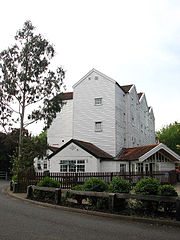
English: The former Buxton Water Mill Viewed from the east. The existence of a watermill at Buxton was recorded in the Domesday book of 1085; the mill was last rebuilt (as a working mill) in 1754 by William Pepper, a merchant living in Buxton, the building being constructed of white painted brick and weatherboard, with a pantile roof. The millstones, used for grinding animal food stuffs and flour, were driven by water power. 98% of the milled wheat was grown locally, and in its heyday Buxton mill produced 1 ton of flour per hour. A silo was added in 1930, followed by a dryer in 1947 and in 1970 the mill was closed; first used as tea rooms then as an art gallery and craft centre, and later as a restaurant, the building was destroyed by a fire in 1991. Reconstructed by architect Keith Reay from 19th century North American pitched pine, salvaged from throughout Great Britain, this was the to-date largest timber-framed reconstruction to take place in the UK. After conversion into a hotel in 1998 the building has since then been converted again, this time into flats. http://www.norfolkmills.co.uk/Watermills/buxton.html |
| Date | |
| Source | From geograph.org.uk |
| Author | Evelyn Simak |
| Attribution (required by the license) | Evelyn Simak / The former Buxton Water Mill / |
| Camera location | | View this and other nearby images on: OpenStreetMap |
|---|
Licensing

|
This image was taken from the Geograph project collection. See this photograph's page on the Geograph website for the photographer's contact details. The copyright on this image is owned by Evelyn Simak and is licensed for reuse under the Creative Commons Attribution-ShareAlike 2.0 license.
|
This file is licensed under the Creative Commons Attribution-Share Alike 2.0 Generic license.
Attribution: Evelyn Simak
- You are free:
- to share – to copy, distribute and transmit the work
- to remix – to adapt the work
- Under the following conditions:
- attribution – You must give appropriate credit, provide a link to the license, and indicate if changes were made. You may do so in any reasonable manner, but not in any way that suggests the licensor endorses you or your use.
- share alike – If you remix, transform, or build upon the material, you must distribute your contributions under the same or compatible license as the original.
File history
Click on a date/time to view the file as it appeared at that time.
| Date/Time | Thumbnail | Dimensions | User | Comment | |
|---|---|---|---|---|---|
| current | 16:08, 7 October 2008 | | 480 × 640 (161 KB) | Northmetpit | {{Information |Description= Picture of the former water mill at Buxton Lammas, Norfolk |Source=[http://www.geograph.org.uk/photo/829528/Geograph] |Date=June 2008 |Author=[http://www.geograph.org.uk/profile/14840/Evely |
File usage
The following pages on the English Wikipedia use this file (pages on other projects are not listed):
Global file usage
The following other wikis use this file:
- Usage on ceb.wikipedia.org
- Usage on cy.wikipedia.org
- Usage on nl.wikipedia.org
- Usage on pl.wikipedia.org
- Usage on www.wikidata.org