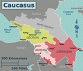
File:Caucasus regions map3.png

Page contents not supported in other languages.
This is a file from the Wikimedia Commons
From Wikipedia, the free encyclopedia

Original file(2,384 × 2,048 pixels, file size: 652 KB, MIME type: image/png)


{{{template}}} According to the article 343¹ of the Georgian Criminal Code, producing, selling and advertizing maps, or other items, both in electronic and print versions, that reflect the violation of the principle of Georgia's territorial integrity, for the purpose of disseminating incorrect information on the territorial integrity of Georgia, is illegal in Georgia, punished by a fine or imprisonment of up to two years.
The boundaries on this map show the de facto situation. This is just one of several different views on the subject (see COM:NPOV).

Summary

Description
English: Own work, based off of File:Caucasus regions map2.png by user:Travelpleb, which itself was based off of File:Caucasus regions map.svg by Peter Fitzgerald and the map of ethno-linguistic groups by Pmx
Date
Source Own work, based on File:Caucasus regions map2.png.
Author Flalf
Other versions

Licensing

I, the copyright holder of this work, hereby publish it under the following license:
w:en:Creative Commons
attribution share alike
This file is licensed under the Creative Commons Attribution-Share Alike 4.0 International license.
You are free:
  • to share – to copy, distribute and transmit the work
  • to remix – to adapt the work
Under the following conditions:
  • attribution – You must give appropriate credit, provide a link to the license, and indicate if changes were made. You may do so in any reasonable manner, but not in any way that suggests the licensor endorses you or your use.
  • share alike – If you remix, transform, or build upon the material, you must distribute your contributions under the same or compatible license as the original.

Captions

Updated map of the Caucasus after the 2020 Nagorno-Karabakh War

8 January 2021

image/png

3ef0d3003aaa1b22c9f644aae01268891320eb1a

650,990 byte

1,789 pixel

2,070 pixel

File history

Click on a date/time to view the file as it appeared at that time.

Date/TimeThumbnailDimensionsUserComment
current13:50, 4 May 2024Thumbnail for version as of 13:50, 4 May 20242,384 × 2,048 (652 KB)Goldenupdating to match the SVG version
22:25, 2 April 2021Thumbnail for version as of 22:25, 2 April 20212,070 × 1,789 (636 KB)Taron Saharyanthere is a Lachin corridor whose existence cannot be ignored
17:22, 8 January 2021Thumbnail for version as of 17:22, 8 January 20212,070 × 1,789 (627 KB)FlalfUploaded own work with UploadWizard
The following pages on the English Wikipedia use this file (pages on other projects are not listed):