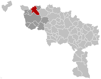
File:Celles Hainaut Belgium Map.png

Page contents not supported in other languages.
This is a file from the Wikimedia Commons
From Wikipedia, the free encyclopedia

Celles_Hainaut_Belgium_Map.png(355 × 278 pixels, file size: 8 KB, MIME type: image/png)

Description
English: Map, municipality belgium Celles
Français : Carte indiquant la localisation de la commune de Celles dans la Province de Hainaut.
Source Own work
Author LennartBolks
Permission
(Reusing this file)
PD
Public domain This work has been released into the public domain by its author, LennartBolks. This applies worldwide.

In some countries this may not be legally possible; if so:
LennartBolks grants anyone the right to use this work for any purpose, without any conditions, unless such conditions are required by law.

Captions

Add a one-line explanation of what this file represents

Items portrayed in this file

depicts

image/png

af6bf9b2373ed98829c68cdc1c835faa45d5b918

8,374 byte

278 pixel

355 pixel

File history

Click on a date/time to view the file as it appeared at that time.

Date/TimeThumbnailDimensionsUserComment
current09:51, 5 March 2007Thumbnail for version as of 09:51, 5 March 2007355 × 278 (8 KB)SiebrandUpdated map by Westermarck
21:34, 28 March 2005Thumbnail for version as of 21:34, 28 March 2005355 × 278 (6 KB)Nicnac25~commonswikiMap, municipality belgium Celles {{PD}} FR; Carte indiquant la localisation de la commune de Celles dans la Province de Hainaut. EN; Map from w:nl:Gebruiker:LennartBolks/kaartenhoekje in Public Domain by the Author choice. [[Category:Maps of provinc
No pages on the English Wikipedia use this file (pages on other projects are not listed).