
File:Chollas View, San Diego, California (15036258503).jpg

Original file (4,000 × 3,000 pixels, file size: 3.55 MB, MIME type: image/jpeg)
| This is a file from the Wikimedia Commons. Information from its description page there is shown below. Commons is a freely licensed media file repository. You can help. |
.jpg)
Summary
| Description |
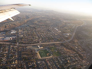
Chollas View is a community in the southeastern section of the city of San Diego. It is bordered by Webster and California State Route 94 on the north, Mount Hope and Interstate 805 on the west, Emerald Hills and Euclid Avenue on the east, and Lincoln Park and the San Diego Trolley on the south. Major thoroughfares include Market Street and 47th Street. Chollas View is named after the large numbers of Cholla cactus that once covered the land. Holy Cross Cemetery opened in the area in 1919. During World War II, a defense housing project was built in the neighborhood. The neighborhood began to develop around the housing project in the 1950s. en.wikipedia.org/wiki/Chollas_View,_San_Diego en.wikipedia.org/wiki/Wikipedia:Text_of_Creative_Commons_... |
| Date | |
| Source | Chollas View, San Diego, California |
| Author | Ken Lund from Reno, Nevada, USA |
| Camera location | | View this and other nearby images on: OpenStreetMap |
|---|
.jpg¶ms=032.709744_N_-117.091892_E_globe:Earth_type:camera_source:Flickr_&language=en)
Licensing
- You are free:
- to share – to copy, distribute and transmit the work
- to remix – to adapt the work
- Under the following conditions:
- attribution – You must give appropriate credit, provide a link to the license, and indicate if changes were made. You may do so in any reasonable manner, but not in any way that suggests the licensor endorses you or your use.
- share alike – If you remix, transform, or build upon the material, you must distribute your contributions under the same or compatible license as the original.
| This image was originally posted to Flickr by Ken Lund at https://flickr.com/photos/75683070@N00/15036258503. It was reviewed on 4 December 2015 by FlickreviewR and was confirmed to be licensed under the terms of the cc-by-sa-2.0. |
File history
Click on a date/time to view the file as it appeared at that time.
| Date/Time | Thumbnail | Dimensions | User | Comment | |
|---|---|---|---|---|---|
| current | 04:06, 4 December 2015 | | 4,000 × 3,000 (3.55 MB) | INeverCry | Transferred from Flickr via Flickr2Commons |
.jpg)