
File:Climate maps of Iran (Köppen-Geiger).png

Size of this preview: 672 × 600 pixels. Other resolutions: 269 × 240 pixels | 538 × 480 pixels | 861 × 768 pixels | 1,147 × 1,024 pixels | 2,000 × 1,785 pixels.
Original file (2,000 × 1,785 pixels, file size: 312 KB, MIME type: image/png)
| This is a file from the Wikimedia Commons. Information from its description page there is shown below. Commons is a freely licensed media file repository. You can help. |
.png)
Summary
| Description |
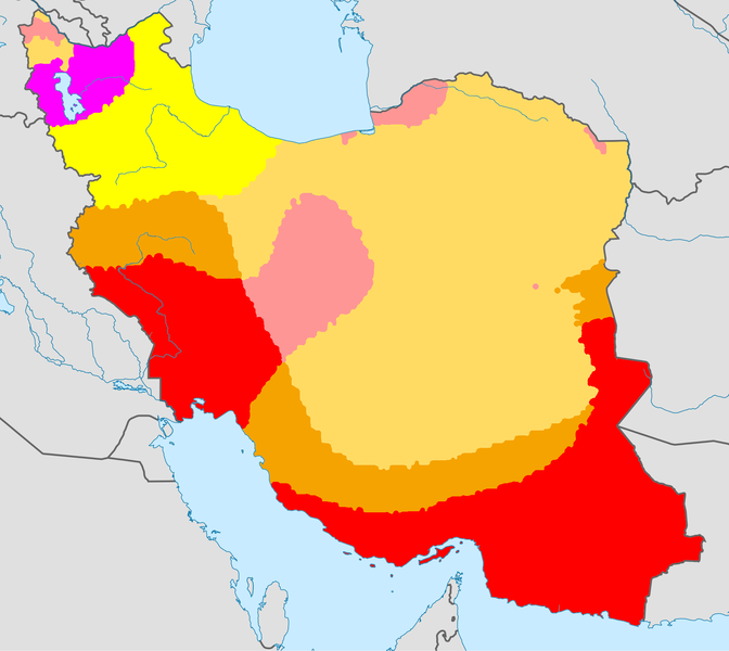
English: Climate map of Iran, using the Köppen-Geiger climate classification |
| Date | (UTC) |
| Source |
This file was derived from: |
| Author |
|
Licensing
This file is licensed under the Creative Commons Attribution-Share Alike 3.0 Unported license.
- You are free:
- to share – to copy, distribute and transmit the work
- to remix – to adapt the work
- Under the following conditions:
- attribution – You must give appropriate credit, provide a link to the license, and indicate if changes were made. You may do so in any reasonable manner, but not in any way that suggests the licensor endorses you or your use.
- share alike – If you remix, transform, or build upon the material, you must distribute your contributions under the same or compatible license as the original.
Original upload log
This image is a derivative work of the following images:
- File:World Köppen Map.png licensed with Cc-by-sa-3.0
- 2011-03-13T12:13:30Z Maphobbyist 4231x2804 (1168443 Bytes) Painted the Caspian Sea as white as it should have been, because the Köppen system is based on the concept that climate types are correlated with the natural vegetation. Thus with Köppen, climate zone boundaries have been s
- 2010-03-05T23:41:54Z Aiyizo 4231x2804 (344162 Bytes) Cropped white space, compressed with pngout. I've also converted the image to indexed mode with an optimal 64 color palette. This introduces minor alaising effects to the region edges, but it gives a massive reduction in fi
- 2007-10-12T22:35:59Z Jeroen 4250x2815 (2188412 Bytes)
- 2007-10-12T22:05:31Z Jeroen 6708x4443 (3366169 Bytes) Citation: '''Peel, M. C., Finlayson, B. L., and McMahon, T. A.: Updated world map of the Köppen-Geiger climate classification, Hydrol. Earth Syst. Sci., 11, 1633-1644, 2007.''' {{Information |Description= Updated world map
- File:Iran_location_map.svg licensed with Cc-by-sa-3.0, GFDL
- 2013-04-15T17:55:21Z NordNordWest 1200x1071 (306314 Bytes) according to http://images.persianblog.ir/516041_B0b76ypr.jpg + Tabas -> South Khorasan province
- 2013-04-12T17:40:10Z Yamaha5 1200x1071 (655114 Bytes) Reverted to version as of 20:08, 11 July 2010
- 2013-04-12T17:38:55Z Yamaha5 1200x1071 (655114 Bytes) Reverted to version as of 20:08, 11 July 2010 in all maps khorasan is like past!
- 2013-03-17T11:30:56Z NordNordWest 1200x1071 (301415 Bytes) upd
- 2010-07-11T20:08:23Z Uwe Dedering 1200x1071 (655114 Bytes) 31. province Alborz
- 2010-02-18T17:44:29Z Uwe Dedering 1200x1071 (721726 Bytes) Bahrain above water, no disputed countries
- 2010-02-18T13:00:48Z Uwe Dedering 1200x1071 (725716 Bytes) {{Information |Description={{en|1=Location map of Iran. Equirectangular projection. Strechted by 118.0%. Geographic limits of the map: * N: 40.0° N * S: 24.5° N * W: 43.5° E * E: 64.0° E Made with Natural Earth. Fre
Uploaded with derivativeFX
File history
Click on a date/time to view the file as it appeared at that time.
| Date/Time | Thumbnail | Dimensions | User | Comment | |
|---|---|---|---|---|---|
| current | 20:39, 21 June 2013 | | 2,000 × 1,785 (312 KB) | Underlying lk | == {{int:filedesc}} == {{Information |Description={{en|1=Climate map of Iran, using the Köppen-Geiger climate classification}} |Source={{Derived from|World_Koppen_Map.png|Iran_location_map.svg|display=50}} |Date=2013-06-21 20:36 (UTC) |Author=*[[:File... |
File usage
No pages on the English Wikipedia use this file (pages on other projects are not listed).
Global file usage
The following other wikis use this file:
- Usage on az.wikipedia.org
- Usage on nn.wikipedia.org
- Usage on te.wikipedia.org
.png)