
File:First second third worlds map.svg

Size of this PNG preview of this SVG file: 800 × 409 pixels. Other resolutions: 320 × 164 pixels | 640 × 327 pixels | 1,024 × 524 pixels | 1,280 × 655 pixels | 2,560 × 1,310 pixels | 860 × 440 pixels.
Original file (SVG file, nominally 860 × 440 pixels, file size: 1.36 MB)
| This is a file from the Wikimedia Commons. Information from its description page there is shown below. Commons is a freely licensed media file repository. You can help. |
| Description |
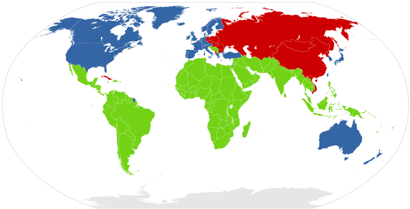
English: Map of the "First", "Second" and "Third" world during the Cold War.
Deutsch: Karte von Erster, Zweiter und Dritter Welt während des Kalten Krieges. Sie basiert auf der damaligen Bedeutung der Einteilung, die sich seitdem geändert hat |
||
| Date | |||
| Source |
Based on |
||
| Author | Canuckguy, Ipankonin, et al. | ||
| Permission (Reusing this file) |
|
File history
Click on a date/time to view the file as it appeared at that time.
| Date/Time | Thumbnail | Dimensions | User | Comment | |
|---|---|---|---|---|---|
| current | 22:48, 16 February 2017 | | 860 × 440 (1.36 MB) | Barakokula31 | Yugoslavia was part of the 3rd world. |
| 11:43, 22 April 2015 |  | 860 × 440 (1.36 MB) | Bova | Reverted to version as of 08:50, 26 July 2013 | |
| 11:35, 22 April 2015 |  | 860 × 440 (1.37 MB) | Bova | Yugoslavia wasn't a part of second world - never. Yugoslavia had a own socialist way, just like India or Egypt and was since 1949 never under control of Russia - it's a fact. Even the first conference of Heads of State or Government of the Non-Aligned... | |
| 08:50, 26 July 2013 |  | 860 × 440 (1.36 MB) | Netrat | see talk page | |
| 12:48, 26 March 2012 |  | 860 × 440 (1.36 MB) | Kintetsubuffalo | Reverted to version as of 08:37, 2 March 2012-no such discussion on talk page | |
| 05:24, 25 March 2012 |  | 860 × 440 (1.36 MB) | J intela | Chaged nambia as in discusion discussion also chaged french guiana and cyprus | |
| 08:37, 2 March 2012 |  | 860 × 440 (1.36 MB) | Kintetsubuffalo | Reverted to version as of 16:19, 24 December 2011-that's because it's a specious argument-upload your own | |
| 21:21, 1 March 2012 |  | 860 × 440 (1.37 MB) | Neko ceko | No one replied to the talk page for over a month. | |
| 16:19, 24 December 2011 |  | 860 × 440 (1.36 MB) | Kintetsubuffalo | Reverted to version as of 01:45, 8 December 2011 | |
| 19:03, 23 December 2011 |  | 860 × 440 (1.37 MB) | Vorziblix | Again, correcting Yugoslavia (since no one replied at the talk page), and again, see the talk page and address issues there first. |
File usage
The following pages on the English Wikipedia use this file (pages on other projects are not listed):
Global file usage
The following other wikis use this file:
- Usage on ar.wikipedia.org
- Usage on cs.wikipedia.org
- Usage on de.wikipedia.org
- Usage on el.wiktionary.org
- Usage on eo.wikipedia.org
- Usage on et.wikipedia.org
- Usage on fa.wikipedia.org
- Usage on fr.wikipedia.org
- Usage on it.wikipedia.org
- Usage on it.wikiquote.org
- Usage on pl.wikipedia.org
- Usage on pl.wiktionary.org
- Usage on pnb.wikipedia.org
- Usage on pt.wikipedia.org
- Usage on ro.wikipedia.org
- Usage on sco.wikipedia.org
- Usage on uk.wikiquote.org
- Usage on ur.wikipedia.org
- Usage on vec.wikipedia.org