
File:GD-EG-Citadelle du Caire-map.png
No higher resolution available.
GD-EG-Citadelle_du_Caire-map.png (510 × 460 pixels, file size: 16 KB, MIME type: image/png)
| This is a file from the Wikimedia Commons. Information from its description page there is shown below. Commons is a freely licensed media file repository. You can help. |
Summary
العربية: قلعة صلاح الدين
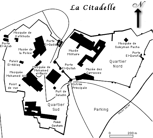
Français : Plan de la Citadelle du Caire (Égypte)
English: Map of the Citadel of Cairo (trans: Qalaʿat Salāḥ ad-Dīn), first fortified in Ayyubid era Egypt.

|
File:GD-EG-Citadelle du Caire-map.svg is a vector version of this file. It should be used in place of this PNG file when not inferior.
File:GD-EG-Citadelle du Caire-map.png → File:GD-EG-Citadelle du Caire-map.svg
For more information, see Help:SVG. |
 |
Source
Français : Dessin de Gérard Ducher (user:Néfermaât).
English: Drawing by Gérard Ducher
Licensing
This file is licensed under the Creative Commons Attribution-Share Alike 2.5 Generic license.
- You are free:
- to share – to copy, distribute and transmit the work
- to remix – to adapt the work
- Under the following conditions:
- attribution – You must give appropriate credit, provide a link to the license, and indicate if changes were made. You may do so in any reasonable manner, but not in any way that suggests the licensor endorses you or your use.
- share alike – If you remix, transform, or build upon the material, you must distribute your contributions under the same or compatible license as the original.
derivative works
Derivative works of this file: GD-EG-Citadelle du Caire-map.svg
File history
Click on a date/time to view the file as it appeared at that time.
| Date/Time | Thumbnail | Dimensions | User | Comment | |
|---|---|---|---|---|---|
| current | 22:07, 13 January 2006 | | 510 × 460 (16 KB) | Néfermaât | == Description == fr: Plan de la Citadelle du Caire Égypte. ==Source== fr: Dessin de Gérard Ducher (user:Néfermaât). Nefermaat == Licence == {{cc-by-sa-2.5}} |
File usage
No pages on the English Wikipedia use this file (pages on other projects are not listed).
Global file usage
The following other wikis use this file:
- Usage on it.wikipedia.org