
File:Shorrolds Road, Fulham (geograph 4394969 by Oast House Archive).jpg

Size of this preview: 800 × 600 pixels. Other resolutions: 320 × 240 pixels | 640 × 480 pixels | 1,024 × 768 pixels.
Original file (1,024 × 768 pixels, file size: 187 KB, MIME type: image/jpeg)
| This is a file from the Wikimedia Commons. Information from its description page there is shown below. Commons is a freely licensed media file repository. You can help. |
Summary
| Description |
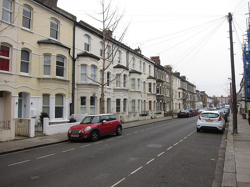
English: The road on which Suzy Lamplugh was showing a man a property, 37 Shorrolds Road, before she disappeared on 28 July 1986. Lamplugh was seen several times outside the property with a man who was smartly dressed and holding a bottle of champagne with a ribbon around it. |
| Date | |
| Source | https://www.geograph.org.uk/more.php?id=4394969 |
| Author | Oast House Archive |
| Other versions | |
| Attribution (required by the license) | Oast House Archive / Shorrolds Road / |
.jpg)
.jpg)
| Camera location | | View this and other nearby images on: OpenStreetMap |
|---|
.jpg¶ms=051.481293_N_-000.200717_E_globe:Earth_type:camera_source:geograph-osgb36(TQ25047735)_heading:225.00&language=en)
| Object location | | View this and other nearby images on: OpenStreetMap |
|---|
.jpg¶ms=051.481120_N_-000.201010_E_globe:Earth_class:object_type:object_source:geograph-osgb36(TQ25027733)_heading:225.00&language=en)
Licensing

|
This image was taken from the Geograph project collection. See this photograph's page on the Geograph website for the photographer's contact details. The copyright on this image is owned by Oast House Archive and is licensed for reuse under the Creative Commons Attribution-ShareAlike 2.0 license.
|
This file is licensed under the Creative Commons Attribution-Share Alike 2.0 Generic license.
Attribution: Oast House Archive
- You are free:
- to share – to copy, distribute and transmit the work
- to remix – to adapt the work
- Under the following conditions:
- attribution – You must give appropriate credit, provide a link to the license, and indicate if changes were made. You may do so in any reasonable manner, but not in any way that suggests the licensor endorses you or your use.
- share alike – If you remix, transform, or build upon the material, you must distribute your contributions under the same or compatible license as the original.
File history
Click on a date/time to view the file as it appeared at that time.
| Date/Time | Thumbnail | Dimensions | User | Comment | |
|---|---|---|---|---|---|
| current | 15:53, 11 July 2022 | | 1,024 × 768 (187 KB) | BarehamOliver | Uploaded a work by Oast House Archive from https://www.geograph.org.uk/more.php?id=4394969 with UploadWizard |
File usage
No pages on the English Wikipedia use this file (pages on other projects are not listed).
.jpg)