
File:Guangzhou Metro physical layout 2010 en.svg

Size of this PNG preview of this SVG file: 466 × 599 pixels. Other resolutions: 187 × 240 pixels | 373 × 480 pixels | 597 × 768 pixels | 796 × 1,024 pixels | 1,593 × 2,048 pixels | 1,400 × 1,800 pixels.
Original file (SVG file, nominally 1,400 × 1,800 pixels, file size: 401 KB)
| This is a file from the Wikimedia Commons. Information from its description page there is shown below. Commons is a freely licensed media file repository. You can help. |
Summary
| Description |
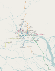
English: Physical layout of Guangzhou Metro system after 2010 expansion.
Base map exported and derived from OpenStreetMap with bounding box 22.7806° N, 113.0515° E–23.4152° N, 113.5870° E at scale 1 : 152226. |
| Date | |
| Source | Own work |
| Author | Kxx |
| Other versions | Derivative works of this file: Guangzhou Metro physical layout 2010 zh-cn.svg |
| Object location | | View this and other nearby images on: OpenStreetMap |
|---|
Licensing
I, the copyright holder of this work, hereby publish it under the following license:
This file is licensed under the Creative Commons Attribution-Share Alike 3.0 Unported license.
- You are free:
- to share – to copy, distribute and transmit the work
- to remix – to adapt the work
- Under the following conditions:
- attribution – You must give appropriate credit, provide a link to the license, and indicate if changes were made. You may do so in any reasonable manner, but not in any way that suggests the licensor endorses you or your use.
- share alike – If you remix, transform, or build upon the material, you must distribute your contributions under the same or compatible license as the original.
File history
Click on a date/time to view the file as it appeared at that time.
| Date/Time | Thumbnail | Dimensions | User | Comment | |
|---|---|---|---|---|---|
| current | 18:48, 2 July 2011 | | 1,400 × 1,800 (401 KB) | Kxx | explicitly specified height, width and viewbox |
| 18:25, 7 January 2011 |  | 1,400 × 1,800 (401 KB) | Kxx | code clean up | |
| 18:24, 7 January 2011 |  | 1,400 × 1,800 (553 KB) | Kxx | simplified paths | |
| 17:22, 7 January 2011 |  | 1,400 × 1,800 (559 KB) | Kxx | "Optimized SVG" output from Inkscape | |
| 17:21, 7 January 2011 |  | 1,400 × 1,800 (719 KB) | Kxx | minor adjustments | |
| 07:29, 7 January 2011 |  | 1,400 × 1,800 (558 KB) | Kxx | "Optimized SVG" output from Inkscape | |
| 07:28, 7 January 2011 |  | 1,400 × 1,800 (718 KB) | Kxx | {{Information |Description={{en|1=Physical layout of Guangzhou Metro system after 2010 expansion. Base map exported from OpenStreetMap with bounding box {{nowrap|22.7806° N, 113.0515° E}}–{{nowrap|23.4152° N, 113.5870° E}} at {{nowrap|scale 1 : 152 |
File usage
No pages on the English Wikipedia use this file (pages on other projects are not listed).