
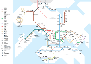
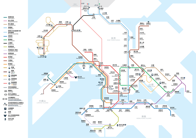
File:Hk-rds2014-wikipedia.png

Size of this preview: 800 × 566 pixels. Other resolutions: 320 × 226 pixels | 640 × 453 pixels | 1,024 × 724 pixels | 1,280 × 905 pixels | 2,560 × 1,810 pixels | 7,016 × 4,961 pixels.
Original file (7,016 × 4,961 pixels, file size: 1.4 MB, MIME type: image/png)
| This is a file from the Wikimedia Commons. Information from its description page there is shown below. Commons is a freely licensed media file repository. You can help. |
Summary
| Description |
English: MTR Route Map with lines mentioned by RDS 2014 中文(香港):包含《鐵路發展策略2014》擬議路線之港鐵路線圖 |
| Date | Same as most recent upload date |
| Source | Own work |
| Author | Xavier114fch |

|
This transport map image could be re-created using vector graphics as an SVG file. This has several advantages; see Commons:Media for cleanup for more information. If an SVG form of this image is available, please upload it and afterwards replace this template with
{{vector version available|new image name}}.
It is recommended to name the SVG file “Hk-rds2014-wikipedia.svg”—then the template Vector version available (or Vva) does not need the new image name parameter. |
Licensing
I, the copyright holder of this work, hereby publish it under the following license:
This file is licensed under the Creative Commons Attribution-Share Alike 4.0 International license.
- You are free:
- to share – to copy, distribute and transmit the work
- to remix – to adapt the work
- Under the following conditions:
- attribution – You must give appropriate credit, provide a link to the license, and indicate if changes were made. You may do so in any reasonable manner, but not in any way that suggests the licensor endorses you or your use.
- share alike – If you remix, transform, or build upon the material, you must distribute your contributions under the same or compatible license as the original.
File history
Click on a date/time to view the file as it appeared at that time.
| Date/Time | Thumbnail | Dimensions | User | Comment | |
|---|---|---|---|---|---|
| current | 15:22, 25 May 2018 | | 7,016 × 4,961 (1.4 MB) | Xavier114fch | East West Line > Tuen Ma Line North South Line > East Rail Line (Same as current name of the line) |
| 04:50, 28 November 2017 |  | 7,016 × 4,961 (1.41 MB) | Xavier114fch | Exhibition > Exhibition Centre | |
| 12:27, 27 November 2017 |  | 7,016 × 4,961 (1.41 MB) | Xavier114fch | Remove logo | |
| 10:12, 27 November 2017 |  | 7,016 × 4,961 (1.42 MB) | Xavier114fch | Updated Sung Wong Toi and To Kwa Wan stations. Siu Ho Wan station as mentioned by EIA reports. | |
| 06:26, 18 September 2014 |  | 7,016 × 4,961 (1.35 MB) | Xavier114fch | User created page with UploadWizard |
File usage
The following pages on the English Wikipedia use this file (pages on other projects are not listed):
Global file usage
The following other wikis use this file:
- Usage on incubator.wikimedia.org
- Usage on ja.wikipedia.org
- Usage on zh-yue.wikipedia.org
- Usage on zh.wikipedia.org