
File:Juniperus deppeana varieties range map 2.png

Size of this preview: 600 × 600 pixels. Other resolutions: 240 × 240 pixels | 480 × 480 pixels | 768 × 768 pixels | 1,024 × 1,024 pixels | 2,048 × 2,048 pixels | 3,980 × 3,980 pixels.
Original file (3,980 × 3,980 pixels, file size: 266 KB, MIME type: image/png)
| This is a file from the Wikimedia Commons. Information from its description page there is shown below. Commons is a freely licensed media file repository. You can help. |
Summary
| Description |
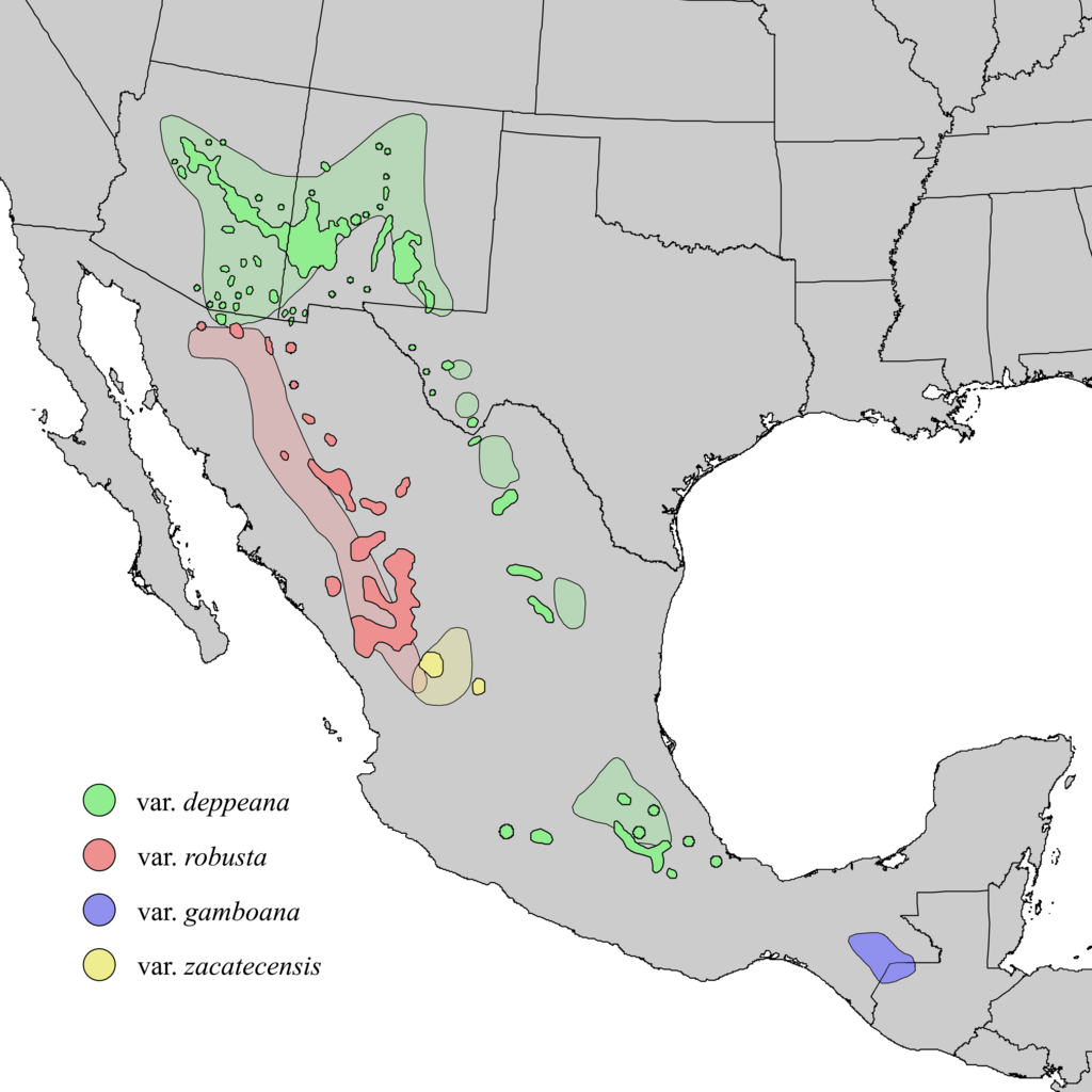
English: Natural distribution map for Juniperus deppeana (alligator juniper). The shaded areas and indicated varieties are from Adams et al. (2006), which mapped out J. deppeana varieties and forms. The darker colors show possible varieties presented the Elbert Little (1971) map populations based only on their proximity to the shaded areas. The var. gamboana population did not appear in the Little (1971) map. It was considered to be a separate species J. gamboana until merged into J. deppeana by Adams (2006). Adams also showed var. patoniana interspersed amongst the var. robusta population, forma sperryi amongst the var. depeana populations of Arizona, New Mexico and Texas, and forma elongata also within the texas population. These were omitted from this map for simplicity. |
| Date | |
| Source | USGS Geosciences and Environmental Change Science Center: Digital Representations of Tree Species Range Maps from: Elbert L. Little, Jr. (1971), Atlas of United States trees, Vol. 1, conifers and important hardwoods: U.S. Department of Agriculture Miscellaneous Publication 1146, 9 p., 200 maps. Additional population data and taxonomic updates from Robert P. Adams and Andrea E. Schwarzbach (2006) "Ifraspecific adjustments in Juniperus Deppeana (Cupressaceae)"; Phytologia 88(3): 227-232. |
| Author | Elbert L. Little, Jr., of the U.S. Department of Agriculture, Forest Service |
Licensing
This work is in the public domain in the United States because it is a work prepared by an officer or employee of the United States Government as part of that person’s official duties under the terms of Title 17, Chapter 1, Section 105 of the US Code.
Note: This only applies to original works of the Federal Government and not to the work of any individual U.S. state, territory, commonwealth, county, municipality, or any other subdivision. This template also does not apply to postage stamp designs published by the United States Postal Service since 1978. (See § 313.6(C)(1) of Compendium of U.S. Copyright Office Practices). It also does not apply to certain US coins; see The US Mint Terms of Use.
|
 | |
| This file has been identified as being free of known restrictions under copyright law, including all related and neighboring rights. | ||
File history
Click on a date/time to view the file as it appeared at that time.
| Date/Time | Thumbnail | Dimensions | User | Comment | |
|---|---|---|---|---|---|
| current | 03:36, 6 December 2013 | | 3,980 × 3,980 (266 KB) | Nonenmac | User created page with UploadWizard |
File usage
The following pages on the English Wikipedia use this file (pages on other projects are not listed):
Global file usage
The following other wikis use this file:
- Usage on ceb.wikipedia.org
- Usage on de.wikipedia.org
- Usage on es.wikipedia.org
- Usage on fr.wikipedia.org
- Usage on is.wikipedia.org
- Usage on it.wikipedia.org
- Usage on uk.wikipedia.org