
File:KMSP Airport Map.png

Size of this preview: 416 × 599 pixels. Other resolutions: 167 × 240 pixels | 333 × 480 pixels | 779 × 1,121 pixels.
Original file (779 × 1,121 pixels, file size: 141 KB, MIME type: image/png)
| This is a file from the Wikimedia Commons. Information from its description page there is shown below. Commons is a freely licensed media file repository. You can help. |

|
File:MSP Airport Diagram.svg is a vector version of this file. It should be used in place of this PNG file when not inferior.
File:KMSP Airport Map.png → File:MSP Airport Diagram.svg
For more information, see Help:SVG. |
 |
Summary
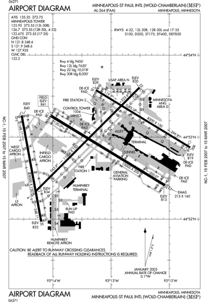
| Description | FAA airport diagram for MSP (Minneapolis-St. Paul International Airport) in Minnesota, United States. |
| Date | Unknown date. Effective: 15 February 2007 - 15 March 2007 |
| Source | http://www.naco.faa.gov/index.asp?xml=naco/online/d_tpp |
| Author | United States Federal Aviation Administration |
| Permission (Reusing this file) |
Public Domain |
Licensing
This image or file is a work of a Federal Aviation Administration employee, taken or made as part of that person's official duties. As a work of the U.S. federal government, the image is in the public domain in the United States.
|
 |
File history
Click on a date/time to view the file as it appeared at that time.
| Date/Time | Thumbnail | Dimensions | User | Comment | |
|---|---|---|---|---|---|
| current | 05:53, 16 February 2007 | | 779 × 1,121 (141 KB) | Phongn | == Summary == {{Information| |Description = FAA airport diagram for MSP (Minneapolis-St. Paul International Airport) in Minnesota, United States. |Source = http://www.naco.faa.gov/index.asp?xml=naco/online/d_tpp |Date = Unknown. Effective: 15 February 200 |
File usage
No pages on the English Wikipedia use this file (pages on other projects are not listed).