
File:KTS-b.jpg
No higher resolution available.
KTS-b.jpg (657 × 436 pixels, file size: 52 KB, MIME type: image/jpeg)
| This is a file from the Wikimedia Commons. Information from its description page there is shown below. Commons is a freely licensed media file repository. You can help. |
Summary
| Description |
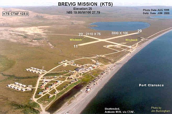
English: Annotated aerial photograph of Brevig Mission Airport (KTS) in Brevig Mission, Alaska, United States. |
| Date |
Photo: August 1999 Data: June 2000 |
| Source |
Image: http://www.alaska.faa.gov/fai/images/SSWDENOR/KTS-b.jpg Web site: http://www.alaska.faa.gov/fai/airports.htm |
| Author | Federal Aviation Administration, Alaskan Region |
| Permission (Reusing this file) |
Public domain |
| Camera location | | View this and other nearby images on: OpenStreetMap |
|---|
Licensing
This image or file is a work of a Federal Aviation Administration employee, taken or made as part of that person's official duties. As a work of the U.S. federal government, the image is in the public domain in the United States.
|
 |
File history
Click on a date/time to view the file as it appeared at that time.
| Date/Time | Thumbnail | Dimensions | User | Comment | |
|---|---|---|---|---|---|
| current | 03:29, 18 September 2008 | | 657 × 436 (52 KB) | Zyxw | {{Information |Description = {{en|1=Annotated aerial photograph of Brevig Mission Airport (KTS) in Brevig Mission, Alaska, United States.}} |Source = Image: http://www.alaska.faa.gov/fai/images/SSWDENOR/KTS-b.jpg<br />Web si |
File usage
The following pages on the English Wikipedia use this file (pages on other projects are not listed):
Global file usage
The following other wikis use this file:
- Usage on ceb.wikipedia.org
- Usage on es.wikipedia.org
- Usage on fa.wikipedia.org
- Usage on ru.wikipedia.org
- Usage on tg.wikipedia.org
- Usage on www.wikidata.org