
File:Karakalpakstan districts.png

Size of this preview: 776 × 600 pixels. Other resolutions: 311 × 240 pixels | 621 × 480 pixels | 994 × 768 pixels | 1,280 × 989 pixels | 2,112 × 1,632 pixels.
Original file (2,112 × 1,632 pixels, file size: 55 KB, MIME type: image/png)
| This is a file from the Wikimedia Commons. Information from its description page there is shown below. Commons is a freely licensed media file repository. You can help. |
Summary
| Description |
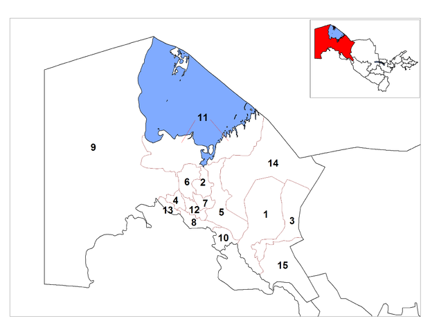
English: Map of the districts (tuman) of the province (viloyat) of Karakalpakstan in Uzbekistan. |
| Date | |
| Source | Own work |
| Author | Rarelibra |
| Other versions |
Derivative works of this file: |
Licensing
| I, the copyright holder of this work, release this work into the public domain. This applies worldwide. In some countries this may not be legally possible; if so: I grant anyone the right to use this work for any purpose, without any conditions, unless such conditions are required by law. |
File history
Click on a date/time to view the file as it appeared at that time.
| Date/Time | Thumbnail | Dimensions | User | Comment | |
|---|---|---|---|---|---|
| current | 16:41, 20 October 2008 | | 2,112 × 1,632 (55 KB) | Rarelibra | bigger numbers Category:Maps of Uzbekistan Category:Districts of Uzbekistan |
| 15:35, 20 October 2008 |  | 2,112 × 1,632 (53 KB) | Rarelibra | {{Information |Description={{en|1=Map of the districts (tuman) of the province (viloyat) of Karakalpakstan in Uzbekistan.}} |Source=Own work by uploader |Author=Rarelibra |Date=10/20/2008 |Permission= |other_versions= }} <!--{{ImageUpl |
File usage
No pages on the English Wikipedia use this file (pages on other projects are not listed).
Global file usage
The following other wikis use this file:
- Usage on es.wikipedia.org
- Usage on mk.wikipedia.org
- Usage on ru.wikipedia.org