Jump to content

File:Kardak (Imia) Islets E-7218.jpg

Page contents not supported in other languages.
This is a file from the Wikimedia Commons
From Wikipedia, the free encyclopedia

Original file (1,835 × 1,391 pixels, file size: 232 KB, MIME type: image/jpeg)

Summary

Description
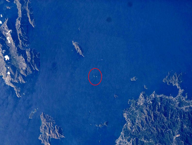
English: Location of the Imia islets in the Aegean Sea.
Türkçe: Kardak (Imia) Adalarının Ege Denizindeki konumu.
Ελληνικά: Τοποθεσία των νησιών Ιμίων (Kardak) στο Αιγαίο Πέλαγος.
Français : Lieu de Kardak (Imia) îles de la mer Egée.
Deutsch: Lage Kardak (Imia) Inseln in der Ägäis.
Español: Lugar de Kardak (IMIA) las islas del mar Egeo.
Português: Localização do Kardak (Imia) ilhas do Mar Egeu.
Italiano: Posizione Kardak (Imia) isole del Mar Egeo.
Nederlands: Locatie van Kardak (Imia) eilanden in de Egeïsche Zee.
Dansk: Placering af Kardak (Imia) øer i Det Ægæiske Hav.
Suomi: Sijainti Kardak (Imia) saarille Egeanmeren.
Svenska: Placering av Kardak (Imia) öar i Egeiska havet.
Polski: Lokalizacja Kardak (Imia) wysp na Morzu Egejskim.
Norsk nynorsk: Plassering av Kardak (Imia) øyene i Egeerhavet.
Azərbaycanca: Ege dənizində Kardak (Imia) adalar mövqe.
Afrikaans: Ligging van Kardak (Imia) eilande in die Egeïese See.
Română: Locul de amplasare a Kardak (Imia) insulele din Marea Egee.
Čeština: Poloha ostrovů Kardak (IMIA) v Egejském moři.
Русский: Расположение Kardak (IMIA) островов в Эгейском море.
中文(中国大陆):Kardak(IMIA)在爱琴海的岛屿的位置。
日本語: エーゲ海のKardak(IMIA)島の場所。
한국어: 에게 해 에게 해의 Kardak (Imia) 섬의 위치.
العربية: موقع الجزر (إيميا) كارداك في بحر إيجة.
עברית: מיקום של איי Kardak (Imia) בים האגאי.
Date
Source http://eol.jsc.nasa.gov/scripts/sseop/QuickView.pl?directory=ESC&ID=ISS022-E-7218
Author NASA
Permission
(Reusing this file)
Conditions of Use of Astronaut Photographs
Camera location37° 03′ 03″ N, 27° 09′ 04″ E Kartographer map based on OpenStreetMap.View this and other nearby images on: OpenStreetMapinfo

Licensing

This image or video was catalogued by Johnson Space Center of the United States National Aeronautics and Space Administration (NASA) under Photo ID: ISS022-E-7218.

This tag does not indicate the copyright status of the attached work. A normal copyright tag is still required. See Commons:Licensing.
Other languages:
This is a retouched picture, which means that it has been digitally altered from its original version. Modifications: cropped,marked,color adjusted and rotated (180°). Modifications made by Maurice07.

Public domain
This file is in the public domain in the United States because it was created by the Image Science & Analysis Laboratory, of the NASA Johnson Space Center. NASA copyright policy states that "NASA material is not protected by copyright unless noted". (NASA media use guidelines or Conditions of Use of Astronaut Photographs). Photo source: ISS022-E-7218.

العربيَّة | Deutsch | English | español | français | italiano | kurdî | македонски | മലയാളം | português | sicilianu | +/−

Captions

Add a one-line explanation of what this file represents

Items portrayed in this file

depicts

5 December 2009

37°3'2.999"N, 27°9'4.000"E

File history

Click on a date/time to view the file as it appeared at that time.

Date/TimeThumbnailDimensionsUserComment
current02:04, 25 December 2012Thumbnail for version as of 02:04, 25 December 20121,835 × 1,391 (232 KB)Maurice07User created page with UploadWizard

The following page uses this file:

Global file usage

The following other wikis use this file:

Metadata