
File:Karte Offshore-Windkraftanlagen in der Deutschen Bucht.png

Size of this preview: 747 × 599 pixels. Other resolutions: 299 × 240 pixels | 599 × 480 pixels | 958 × 768 pixels | 1,277 × 1,024 pixels | 2,553 × 2,048 pixels | 4,342 × 3,483 pixels.
Original file (4,342 × 3,483 pixels, file size: 2.61 MB, MIME type: image/png)
| This is a file from the Wikimedia Commons. Information from its description page there is shown below. Commons is a freely licensed media file repository. You can help. |
Summary
| Description |
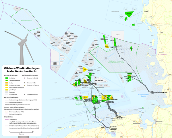
Deutsch: Karte der Offshore-Windkraftanlagen in der Deutschen Bucht sowie deren Kabelanbindungen
English: Map of offshore wind farms and connecting power cables in the German Bight |
|||
| Date | see file history | |||
| Source |
Own work, using data and information from these web sites: |
|||
| Creator | ||||
| Permission (Reusing this file) |
This file is licensed under the Creative Commons Attribution-Share Alike 2.0 Generic license.
Sie dürfen das Bild zu den folgenden Bedingungen nutzen:
|
|||
| Georeferencing | If inappropriate please set warp_status = skip to hide. | |||
| Other versions |
|


File history
Click on a date/time to view the file as it appeared at that time.
| Date/Time | Thumbnail | Dimensions | User | Comment | |
|---|---|---|---|---|---|
| current | 08:13, 13 June 2020 | | 4,342 × 3,483 (2.61 MB) | Chumwa | update |
| 20:23, 21 January 2020 |  | 4,342 × 3,483 (2.62 MB) | Chumwa | update | |
| 21:50, 1 September 2019 |  | 4,342 × 3,483 (2.61 MB) | Chumwa | update | |
| 05:28, 7 July 2019 |  | 4,342 × 3,483 (2.61 MB) | Chumwa | ||
| 21:40, 4 September 2018 |  | 4,342 × 3,483 (2.61 MB) | Chumwa | update | |
| 15:10, 23 June 2018 |  | 4,342 × 3,483 (2.61 MB) | Chumwa | corr | |
| 14:46, 22 June 2018 |  | 4,342 × 3,483 (2.61 MB) | Chumwa | update | |
| 10:30, 6 January 2018 |  | 4,342 × 3,483 (2.54 MB) | Chumwa | update | |
| 20:08, 21 June 2017 |  | 4,342 × 3,483 (2.54 MB) | Chumwa | update | |
| 07:21, 7 May 2017 |  | 4,342 × 3,483 (2.54 MB) | Chumwa |
File usage
The following pages on the English Wikipedia use this file (pages on other projects are not listed):
Global file usage
The following other wikis use this file:
- Usage on da.wikipedia.org
- Usage on de.wikipedia.org
- Stromnetz
- Doggerbank
- Deutsche Bucht
- Benutzer:Chumwa
- Wikipedia:Kartenwerkstatt/Kartenwünsche
- Offshore-Windpark alpha ventus
- FINO-Forschungsplattformen
- Offshore-Windpark Butendiek
- Liste der Offshore-Windparks
- Offshore-Windpark
- Offshore-Windpark Borkum Riffgrund
- Offshore-Windpark Amrumbank West
- Offshore-Windpark Nordsee Ost
- Offshore-Windpark Sandbank
- Offshore-Windpark DanTysk
- Offshore-Windpark Nördlicher Grund
- Offshore-Windpark Global Tech I
- Offshore-Windpark Gode Wind I
- BARD Offshore 1
- Trianel Windpark Borkum
- Offshore-Windpark Gode Wind II
- Offshore-Windpark Hohe See
- Offshore-Windpark He dreiht
- Offshore-Windpark Meerwind
- Offshore-Windpark Veja Mate
- BorWin1
- Nordic Yards
- Innogy
- Offshore-Windpark Horns Rev
- Liste der Schaltanlagen im Höchstspannungsnetz in Deutschland
- BorWin Alpha
- Umspannplattform
- Hafen-Kooperation Offshore-Häfen Nordsee SH
- Offshore-Windpark Riffgat
- Offshore-Windpark Albatros
- Offshore-Netzplan
- Umspannwerk Büttel
- Offshore-HGÜ-Systeme
- BorWin Gamma
- Offshore-Windpark Merkur
- Wikipedia:Kartenwerkstatt/Archiv/2014-07
- Wikipedia:Kartenwerkstatt/Karte des Tages/Galerie
- Benutzer Diskussion:Chumwa/Archiv/2015/2. Quartal
- Offshore-Windpark Gemini
- Benutzer:Chumwa/SomeOfMyFiles
- Offshore-Windpark Nordsee One
View more global usage of this file.