
File:Karte Zweiter Villmergerkrieg 1712.png

Size of this preview: 800 × 507 pixels. Other resolutions: 320 × 203 pixels | 640 × 406 pixels | 1,024 × 650 pixels | 1,280 × 812 pixels | 3,000 × 1,903 pixels.
Original file (3,000 × 1,903 pixels, file size: 616 KB, MIME type: image/png)
| This is a file from the Wikimedia Commons. Information from its description page there is shown below. Commons is a freely licensed media file repository. You can help. |
Summary
| Description |
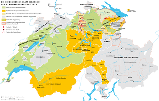
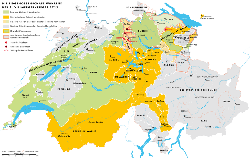
Deutsch: Karte der Eidgenossenschaft während des 2. Villmergerkrieges 1712 |
| Date | |
| Source | Own work |
| Author | Sidonius |
You may use my work outside wikipedia for free as long as you name me as the author. If you would like to use my work in a print medium, please send me a specimen copy.
Contact me if you have questions regarding the license or if you want individual changes to the map (marco.zanoli at hotmail.ch). This file is licensed under the Creative Commons Attribution-Share Alike 4.0 International license. Attribution: Marco Zanoli
|
Licensing
I, the copyright holder of this work, hereby publish it under the following license:
This file is licensed under the Creative Commons Attribution 3.0 Unported license.
- You are free:
- to share – to copy, distribute and transmit the work
- to remix – to adapt the work
- Under the following conditions:
- attribution – You must give appropriate credit, provide a link to the license, and indicate if changes were made. You may do so in any reasonable manner, but not in any way that suggests the licensor endorses you or your use.
File history
Click on a date/time to view the file as it appeared at that time.
| Date/Time | Thumbnail | Dimensions | User | Comment | |
|---|---|---|---|---|---|
| current | 04:58, 4 July 2010 | | 3,000 × 1,903 (616 KB) | DcoetzeeBot | Remove watermark, add author and license data to image metadata, decrease filesize with pngcrush |
| 13:43, 30 March 2009 |  | 3,000 × 1,903 (939 KB) | Sidonius | Verbesserungen | |
| 17:31, 25 March 2009 |  | 3,000 × 1,990 (938 KB) | Sidonius | {{Information |Description={{de|1=Karte der Eidgenossenschaft während des 2. Villmergerkrieges 1712}} |Source=Eigenes Werk (own work) |Author=Sidonius |Date=2009.03.25 |Permission= |other_versions= }} {{Attribu |
File usage
The following pages on the English Wikipedia use this file (pages on other projects are not listed):
Global file usage
The following other wikis use this file:
- Usage on als.wikipedia.org
- Usage on de.wikipedia.org
- Usage on fa.wikipedia.org
- Usage on fr.wikipedia.org
- Usage on ko.wikipedia.org
- Usage on nl.wikipedia.org
- Usage on pt.wikipedia.org
- Usage on www.wikidata.org