
File:Krasnojarski-krai-boguchansky.PNG

Size of this preview: 417 × 600 pixels. Other resolutions: 167 × 240 pixels | 334 × 480 pixels | 534 × 768 pixels | 712 × 1,024 pixels | 1,424 × 2,048 pixels | 2,696 × 3,878 pixels.
Original file (2,696 × 3,878 pixels, file size: 193 KB, MIME type: image/png)
| This is a file from the Wikimedia Commons. Information from its description page there is shown below. Commons is a freely licensed media file repository. You can help. |
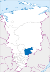
| Description | Map of Krasnoyarsk Krai in Albers Equal-Area Conic projection (Central Meridian = 95° E) |
| Date | (UTC) |
| Source | |
| Author |
|
| This is a retouched picture, which means that it has been digitally altered from its original version. The original can be viewed here: Krasnojarski-krai.png:
|
I, the copyright holder of this work, hereby publish it under the following licenses:
This file is licensed under the Creative Commons Attribution-Share Alike 3.0 Unported license.
- You are free:
- to share – to copy, distribute and transmit the work
- to remix – to adapt the work
- Under the following conditions:
- attribution – You must give appropriate credit, provide a link to the license, and indicate if changes were made. You may do so in any reasonable manner, but not in any way that suggests the licensor endorses you or your use.
- share alike – If you remix, transform, or build upon the material, you must distribute your contributions under the same or compatible license as the original.

|
Permission is granted to copy, distribute and/or modify this document under the terms of the GNU Free Documentation License, Version 1.2 or any later version published by the Free Software Foundation; with no Invariant Sections, no Front-Cover Texts, and no Back-Cover Texts. A copy of the license is included in the section entitled GNU Free Documentation License. |
You may select the license of your choice.
Original upload log
This image is a derivative work of the following images:
- File:Krasnojarski-krai.png licensed with Cc-by-sa-3.0, GFDL
- 2008-03-08T09:29:58Z Koryakov Yuri 2696x3878 (111960 Bytes) Decreasing resolution to avoid "Error creating thumbnail: Invalid thumbnail parameters" message.
- 2008-03-08T09:27:21Z Koryakov Yuri 3595x5171 (159907 Bytes) {{Information |Description=Map of Krasnoyarsk Krai in Albers Equal-Area Conic projection (Central Meridian = 95° E) |Source= self-made |Date=March 2008 |Author=[[:ru:Участник:Koryakov Yuri| Koryakov Yuri]] |other_ver
Uploaded with derivativeFX
File history
Click on a date/time to view the file as it appeared at that time.
| Date/Time | Thumbnail | Dimensions | User | Comment | |
|---|---|---|---|---|---|
| current | 09:17, 28 August 2017 | | 2,696 × 3,878 (193 KB) | RosssW | Уточнение границ Таймырского Долгано-Ненецкого района и Норильска |
| 12:38, 2 April 2010 |  | 2,696 × 3,878 (114 KB) | Khanson | Error in position | |
| 12:34, 2 April 2010 |  | 2,696 × 3,878 (114 KB) | Khanson | {{Information |Description=Map of Krasnoyarsk Krai in Albers Equal-Area Conic projection (Central Meridian = 95° E) |Source=*File:Krasnojarski-krai.png |Date=2010-04-02 12:33 (UTC) |Author=*File:Krasnojarski-krai.png: [[:ru:Участник:K |
File usage
No pages on the English Wikipedia use this file (pages on other projects are not listed).
Global file usage
The following other wikis use this file:
- Usage on be.wikipedia.org
- Usage on ce.wikipedia.org
- Usage on hu.wikipedia.org
- Usage on hy.wikipedia.org
- Usage on pl.wikipedia.org
- Usage on ru.wikipedia.org
- Usage on sr.wikipedia.org
- Usage on uk.wikipedia.org
- Usage on www.wikidata.org
- Usage on zh-min-nan.wikipedia.org