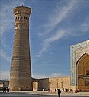
File:Le minaret et la mosquée Kalon (Boukhara, Ouzbékistan) (5658826884).jpg
Appearance

Size of this preview: 800 × 535 pixels. Other resolutions: 320 × 214 pixels | 640 × 428 pixels | 1,024 × 685 pixels | 1,280 × 857 pixels | 1,793 × 1,200 pixels.
Original file (1,793 × 1,200 pixels, file size: 1.44 MB, MIME type: image/jpeg)
File history
Click on a date/time to view the file as it appeared at that time.
| Date/Time | Thumbnail | Dimensions | User | Comment | |
|---|---|---|---|---|---|
| current | 17:22, 15 February 2013 |  | 1,793 × 1,200 (1.44 MB) | File Upload Bot (Magnus Manske) | Transferred from Flickr by User:russavia |
File usage
The following 21 pages use this file:
- Ak Mosque
- Baland Mosque
- Bibi-Khanym Mosque
- Bolo Haouz Mosque
- Chor Minor
- Dzhuma Mosque, Tashkent
- Hasanmurod Qushbegi mosque
- Juma Mosque (Khiva)
- Kalan Mosque
- Kalyan Minaret
- Khonakhan Mosque
- Langarota Mosque
- List of World Heritage Sites in Uzbekistan
- List of mosques in Uzbekistan
- Magok-i-Attari Mosque
- Magok-i-Kurpa Mosque
- Po-i-Kalyan
- Uzbekistan
- User:JahlilMA/sandbox
- User:Jlin57/sandbox/Po-i-Kalyan
- Template:Mosques in Uzbekistan
Global file usage
The following other wikis use this file:
- Usage on ar.wikipedia.org
- Usage on az.wikipedia.org
- Usage on ba.wikipedia.org
- Usage on be.wikipedia.org
- Usage on bg.wikipedia.org
- Usage on bn.wikipedia.org
- Usage on da.wikipedia.org
- Usage on de.wikipedia.org
- Usage on de.wikivoyage.org
- Usage on el.wikipedia.org
- Usage on eo.wikivoyage.org
- Usage on fa.wikipedia.org
- Usage on fi.wikipedia.org
- Usage on fr.wikipedia.org
- Usage on he.wikivoyage.org
- Usage on kab.wikipedia.org
- Usage on ka.wikipedia.org
- Usage on kk.wikipedia.org
- Usage on ko.wikipedia.org
- Usage on lv.wikipedia.org
- Usage on mad.wikipedia.org
- Usage on mk.wikipedia.org
- Usage on mt.wikipedia.org
- Usage on no.wikipedia.org
- Usage on pl.wikipedia.org
- Usage on pl.wikivoyage.org
- Usage on pnb.wikipedia.org
View more global usage of this file.

