
File:Leslie 2000 rainfall.gif

Size of this preview: 549 × 599 pixels. Other resolutions: 220 × 240 pixels | 440 × 480 pixels | 856 × 934 pixels.
Original file (856 × 934 pixels, file size: 25 KB, MIME type: image/gif)
| This is a file from the Wikimedia Commons. Information from its description page there is shown below. Commons is a freely licensed media file repository. You can help. |
Summary
| Description |
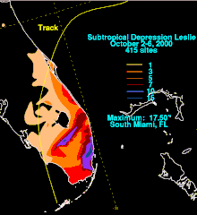
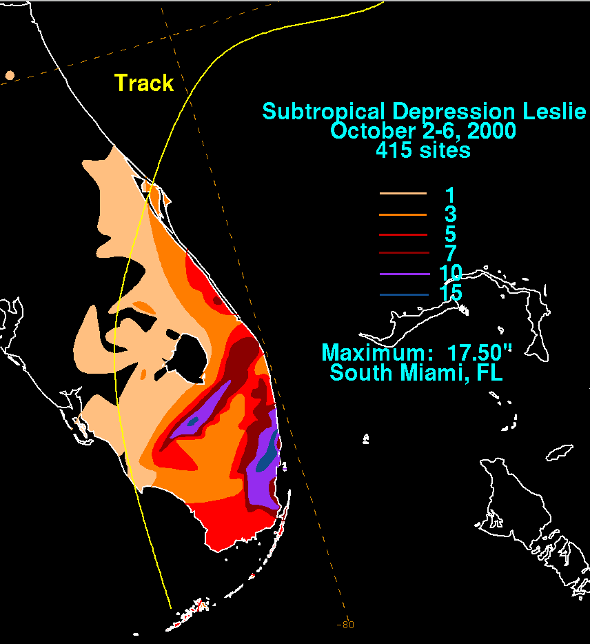
English: Storm total rainfall map of Tropical Storm Leslie during October 2000. |
|||
| Date | ||||
| Source | WPC tropical cyclone rainfall data | |||
| Author | David Roth, Weather Prediction Center, Camp Springs, Maryland | |||
| Permission (Reusing this file) |
|
File history
Click on a date/time to view the file as it appeared at that time.
| Date/Time | Thumbnail | Dimensions | User | Comment | |
|---|---|---|---|---|---|
| current | 23:24, 23 March 2013 | | 856 × 934 (25 KB) | Hurricanefan24 | update |
| 23:47, 21 June 2006 |  | 850 × 869 (819 KB) | Hurricanehink | {{Information |Description=Rainfall totals from Leslie (2000) |Source=http://www.hpc.ncep.noaa.gov/tropical/rain/leslie2000.html |Date=2006-06-21 |Author=Hydrometeorological Prediction Center |Permission={{PD-USGov-NOAA}} |other_versions= }} [[Category:2 | |
| 22:40, 4 February 2006 |  | 850 × 869 (819 KB) | Thegreatdr | Created by David Roth of the Hydrometeorological Prediction Center in Camp Springs, MD |
File usage
The following pages on the English Wikipedia use this file (pages on other projects are not listed):