
File:LuxembourgPartitionsMap francais.jpg
No higher resolution available.
LuxembourgPartitionsMap_francais.jpg (433 × 588 pixels, file size: 111 KB, MIME type: image/jpeg)
| This is a file from the Wikimedia Commons. Information from its description page there is shown below. Commons is a freely licensed media file repository. You can help. |

|
This historical map image could be re-created using vector graphics as an SVG file. This has several advantages; see Commons:Media for cleanup for more information. If an SVG form of this image is available, please upload it and afterwards replace this template with
{{vector version available|new image name}}.
It is recommended to name the SVG file “LuxembourgPartitionsMap francais.svg”—then the template Vector version available (or Vva) does not need the new image name parameter. |


Summary
| Description |
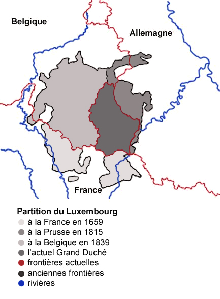
English: Map showing the partition of Luxembourg through the centuries, with French explanations.
Français : Carte montrant la partition du Luxembourg à travers les siècles. |
| Date | |
| Source |
|
| Author | Spanish_Inquisition |
| Other versions |
|


Licensing
| I, the copyright holder of this work, release this work into the public domain. This applies worldwide. In some countries this may not be legally possible; if so: I grant anyone the right to use this work for any purpose, without any conditions, unless such conditions are required by law. |
File history
Click on a date/time to view the file as it appeared at that time.
| Date/Time | Thumbnail | Dimensions | User | Comment | |
|---|---|---|---|---|---|
| current | 09:11, 4 August 2007 | | 433 × 588 (111 KB) | Noelclem | |
| 08:22, 4 August 2007 |  | 433 × 588 (101 KB) | Noelclem | ||
| 15:40, 3 August 2007 |  | 433 × 588 (49 KB) | Iunity | correction orthographe | |
| 14:59, 3 September 2006 |  | 433 × 588 (85 KB) | Spanish Inquisition | Map showing the partition of Luxembourg thorugh the centuries with french expanantions. Modification of the image LuxembourgPartitionsMap.png by user:QuartierLatin1968 14:10, 22 Apr 2005 (UTC). Author: user:Spanish_Inquisition Date: 3rd September 2006 |
File usage
The following pages on the English Wikipedia use this file (pages on other projects are not listed):
Global file usage
The following other wikis use this file:
- Usage on als.wikipedia.org
- Usage on ca.wikipedia.org
- Usage on fr.wikipedia.org
- Luxembourg
- Histoire du Luxembourg
- Formation territoriale de la Belgique
- Frontière entre la France et le Luxembourg
- Wikipédia:Atelier graphique/Images à améliorer/Archives/Août 2007
- Frontière entre la Belgique et le Luxembourg
- Évolution territoriale du Luxembourg
- Frontières du Luxembourg
- Grand-duché de Luxembourg (1815-1890)
- Usage on pcd.wikipedia.org
- Usage on pl.wikipedia.org
- Usage on pt.wikipedia.org
- Usage on uk.wikipedia.org