
File:MRT map NSNECC.svg

Size of this PNG preview of this SVG file: 800 × 457 pixels. Other resolutions: 320 × 183 pixels | 640 × 366 pixels | 1,024 × 585 pixels | 1,280 × 732 pixels | 2,560 × 1,463 pixels | 1,709 × 977 pixels.
Original file (SVG file, nominally 1,709 × 977 pixels, file size: 157 KB)
| This is a file from the Wikimedia Commons. Information from its description page there is shown below. Commons is a freely licensed media file repository. You can help. |
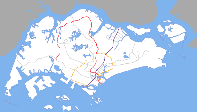
| Description | SVG map of North South, North East & Circle MRT Line in Singapore |
| Source | Own work |
| Author | Oahiyeel |
| SVG development |
Licensing
I, the copyright holder of this work, hereby publish it under the following license:
| This file is made available under the Creative Commons CC0 1.0 Universal Public Domain Dedication. | |
| The person who associated a work with this deed has dedicated the work to the public domain by waiving all of their rights to the work worldwide under copyright law, including all related and neighboring rights, to the extent allowed by law. You can copy, modify, distribute and perform the work, even for commercial purposes, all without asking permission.
|
File history
Click on a date/time to view the file as it appeared at that time.
| Date/Time | Thumbnail | Dimensions | User | Comment | |
|---|---|---|---|---|---|
| current | 13:38, 22 January 2014 | | 1,709 × 977 (157 KB) | Seloloving | NEL alignment updated. |
| 19:13, 1 September 2012 |  | 1,709 × 915 (116 KB) | Seloloving | Added TSL and TWE | |
| 06:13, 25 November 2008 |  | 1,709 × 915 (135 KB) | DCvibes529 | {{Information |Description=SVG map of North South, North East & Circle MRT Line in Singapore |Source=Self made |Date= |Author=Oahiyeel |Permission={{cc-by-sa-2.5}} |other_versions= }} Category:MRT locator maps of Singapore [[Category:Public transport |
File usage
No pages on the English Wikipedia use this file (pages on other projects are not listed).
Global file usage
The following other wikis use this file: