
File:Machane Jisrael street.jpg

Size of this preview: 450 × 600 pixels. Other resolutions: 180 × 240 pixels | 360 × 480 pixels | 675 × 900 pixels.
Original file (675 × 900 pixels, file size: 461 KB, MIME type: image/jpeg)
| This is a file from the Wikimedia Commons. Information from its description page there is shown below. Commons is a freely licensed media file repository. You can help. |
| Description |
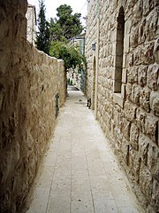
Čeština: Ulička v Machane Jisra'el (jeruzalémská čtvrť) English: Lane in Machane Jisrael (neighbourhood in Jerusalem) עברית: סמטא במחנה ישראל]]
Français : Jérusalem centre - Quartier Mahane Israel, ruelle HAMA'ARAVIM (près de Mamilla). |
|||
| Date | 12 June 2007 (original upload date) | |||
| Source | Transferred from he.wikipedia to Commons. | |||
| Author | The original uploader was תמרה at Hebrew Wikipedia. | |||
| Permission (Reusing this file) |
|
|||
| Other versions |
|


| Camera location | | View this and other nearby images on: OpenStreetMap |
|---|
Original upload log
The original description page was here. All following user names refer to he.wikipedia.
- 2007-06-12 21:31 תמרה 675×900×8 (471572 bytes) {{מידע| |תיאור=סמטא במחנה ישראל |מקור=צילמתי |תאריך יצירה=2007 |יוצר=תמרה |אישורים והיתרים={{ייחוס}} |גרסאות אחרות= }}
File history
Click on a date/time to view the file as it appeared at that time.
| Date/Time | Thumbnail | Dimensions | User | Comment | |
|---|---|---|---|---|---|
| current | 17:52, 28 November 2007 | | 675 × 900 (461 KB) | Daniel Baránek | {{Information |Description={{cs|Ulička v Machane Jisra'el (jeruzalémská čtvrť)}}{{en|Line in Machane Jisrael (neighbourhood in Jerusalem)}}{{he|סמטא במחנה ישראל]] |Source=Transfered from [http://he.wikipedia.or |
File usage
No pages on the English Wikipedia use this file (pages on other projects are not listed).
Global file usage
The following other wikis use this file:
- Usage on he.wikipedia.org