
File:Marchwood Incinerator - geograph.org.uk - 1107922.jpg
No higher resolution available.
Marchwood_Incinerator_-_geograph.org.uk_-_1107922.jpg (640 × 427 pixels, file size: 67 KB, MIME type: image/jpeg)
| This is a file from the Wikimedia Commons. Information from its description page there is shown below. Commons is a freely licensed media file repository. You can help. |
Summary
| Description |
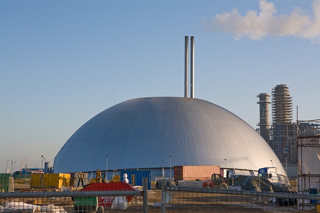
English: Marchwood Incinerator Seen from North Road, Marchwood Industrial Park. Marchwood Incinerator is more correctly termed Marchwood Energy Recovery Facility, since it burns waste and generates upto 14 MW of electrical power for the national grid (see Marchwood ERF in http://www.veoliaenvironmentalservices.co.uk/pages/publications.asp ). According to Hampshire County Council the building is dome-shaped for aesthetic reasons - because it helps to make the incinerator more acceptable to the public - at an additional capital cost of 25%. The chimneys at right are part of the unrelated Marchwood Power Station, under construction. |
| Date | |
| Source | From geograph.org.uk |
| Author | Peter Facey |
| Attribution (required by the license) | Peter Facey / Marchwood Incinerator / |
| Camera location | | View this and other nearby images on: OpenStreetMap |
|---|
_heading:112.00&language=en)
| Object location | | View this and other nearby images on: OpenStreetMap |
|---|
_heading:112.00&language=en)
Licensing

|
This image was taken from the Geograph project collection. See this photograph's page on the Geograph website for the photographer's contact details. The copyright on this image is owned by Peter Facey and is licensed for reuse under the Creative Commons Attribution-ShareAlike 2.0 license.
|
This file is licensed under the Creative Commons Attribution-Share Alike 2.0 Generic license.
Attribution: Peter Facey
- You are free:
- to share – to copy, distribute and transmit the work
- to remix – to adapt the work
- Under the following conditions:
- attribution – You must give appropriate credit, provide a link to the license, and indicate if changes were made. You may do so in any reasonable manner, but not in any way that suggests the licensor endorses you or your use.
- share alike – If you remix, transform, or build upon the material, you must distribute your contributions under the same or compatible license as the original.
File history
Click on a date/time to view the file as it appeared at that time.
| Date/Time | Thumbnail | Dimensions | User | Comment | |
|---|---|---|---|---|---|
| current | 18:12, 24 February 2011 | | 640 × 427 (67 KB) | GeographBot | == {{int:filedesc}} == {{Information |description={{en|1=Marchwood Incinerator Seen from North Road, Marchwood Industrial Park. Marchwood Incinerator is more correctly termed Marchwood Energy Recovery Facility, since it burns waste and generates upto 14 M |
File usage
The following pages on the English Wikipedia use this file (pages on other projects are not listed):
Global file usage
The following other wikis use this file:
- Usage on www.wikidata.org