
File:Metro Indianapolis.PNG
No higher resolution available.
Metro_Indianapolis.PNG (339 × 514 pixels, file size: 21 KB, MIME type: image/png)
| This is a file from the Wikimedia Commons. Information from its description page there is shown below. Commons is a freely licensed media file repository. You can help. |
Summary
| Description |
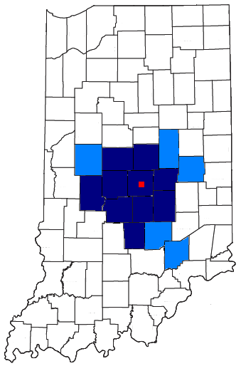
English: Metro Indianapolis |
| Source | Map and displayed information is from the US Census. [1] and [2] |
| Author |
Licensing
This image or file is a work of a United States Census Bureau employee, taken or made as part of that person's official duties. As a work of the U.S. federal government, the image is in the public domain.
|
 |
File history
Click on a date/time to view the file as it appeared at that time.
| Date/Time | Thumbnail | Dimensions | User | Comment | |
|---|---|---|---|---|---|
| current | 13:58, 26 July 2008 | | 339 × 514 (21 KB) | Nyttend | == Summary == Map and displayed information is from the US Census. [http://ftp2.census.gov/geo/maps/general_ref/stco_outline/cen2k_pgsz/stco_IN.pdf] and [http://www.census.gov/geo/www/maps/msa_maps2005/msa2005_previews_html/cbsa_csa_us_wall_1205.html] == |
| 18:46, 31 July 2007 |  | 339 × 514 (21 KB) | Frank12 | Map and displayed information is from the US Census. [http://ftp2.census.gov/geo/maps/general_ref/stco_outline/cen2k_pgsz/stco_IN.pdf] and [http://www.census.gov/geo/www/maps/msa_maps2005/msa2005_previews_html/cbsa_csa_us_wall_1205.html] |
File usage
No pages on the English Wikipedia use this file (pages on other projects are not listed).