
File:MiG-23 Bn Aircraft.jpg

Size of this preview: 800 × 600 pixels. Other resolutions: 320 × 240 pixels | 640 × 480 pixels | 1,024 × 768 pixels | 1,280 × 960 pixels | 2,560 × 1,920 pixels | 4,032 × 3,024 pixels.
Original file (4,032 × 3,024 pixels, file size: 3.91 MB, MIME type: image/jpeg)
| This is a file from the Wikimedia Commons. Information from its description page there is shown below. Commons is a freely licensed media file repository. You can help. |
Summary
| Description |
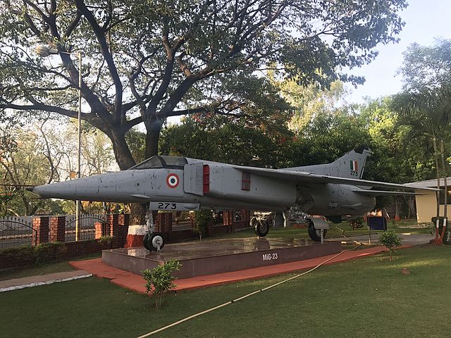
English: This is MiG-23 Aircraft which is the first swing wing fighter to be inducted into the IAF. The aricraft was designed by the Mikoyan Gurevich design bureau of the erstwhile USSR and manufactured in 1982. The aircraft with No SM - 273 is the last MiG-23 Bn to fly in the world and landed at Pune on 26th March 2009. This aircraft was employed in Kashmir Valley during Operation Meghdoot for securing Siachen Glacier in Northern Ladakh. In 1985, MiG-23 Bn had got the unique distinction for being the first fighter aircraft ever to cross Banihal Pass in Jammu and Kashmir by night. On May 24, 1999 during the operation Safed Sagar, the MiG-23 Bn went into the action, targeting enemy position at Tiger Hill with 57 mm rocket and 500 kgs bombs. The aircraft has the distinction of being the aircraft type to fire maximum weapon load over enemy position in Kargil. MiG-23 Bn served the country splendidly for a period of 27 years and flew more than 154,000 hours into the Indian skies. |
| Source | Own work |
| Author | Sanket Oswal |
| Camera location | | View this and other nearby images on: OpenStreetMap |
|---|
Licensing
I, the copyright holder of this work, hereby publish it under the following license:
This file is licensed under the Creative Commons Attribution-Share Alike 4.0 International license.
- You are free:
- to share – to copy, distribute and transmit the work
- to remix – to adapt the work
- Under the following conditions:
- attribution – You must give appropriate credit, provide a link to the license, and indicate if changes were made. You may do so in any reasonable manner, but not in any way that suggests the licensor endorses you or your use.
- share alike – If you remix, transform, or build upon the material, you must distribute your contributions under the same or compatible license as the original.
This image was uploaded as part of Wiki Loves Uniformed services (India)
|
File history
Click on a date/time to view the file as it appeared at that time.
| Date/Time | Thumbnail | Dimensions | User | Comment | |
|---|---|---|---|---|---|
| current | 11:52, 1 June 2017 | | 4,032 × 3,024 (3.91 MB) | Sankoswal | User created page with UploadWizard |
File usage
The following pages on the English Wikipedia use this file (pages on other projects are not listed):
Global file usage
The following other wikis use this file:
- Usage on cs.wikipedia.org
- Usage on te.wikipedia.org