
File:Munson Valley Historic District map.png
No higher resolution available.
Munson_Valley_Historic_District_map.png (283 × 323 pixels, file size: 51 KB, MIME type: image/png)
| This is a file from the Wikimedia Commons. Information from its description page there is shown below. Commons is a freely licensed media file repository. You can help. |
| Description |
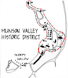
English: Map of the Munson Valley Historic District in Crater Lake National Park, Oregon, United States. The district is listed on the US National Register of Historic Places (NRHP). |
| Date | |
| Source |
Crater Lake Historic Resource Study by Linda W. Green, published by National Park Service, United States Department of the Interior, June 1984 http://www.nps.gov/archive/crla/munson/munson3d.htm |
| Author |
Linda W. Green, National Park Service Pete Forsyth also added the red color highlight to the outline. |
| Permission (Reusing this file) |
PD-USGOV |
| Other versions | File:Munson Valley Historic District map.jpg |
Licensing
| This image or media file contains material based on a work of a National Park Service employee, created as part of that person's official duties. As a work of the U.S. federal government, such work is in the public domain in the United States. See the NPS website and NPS copyright policy for more information. |
| Annotations | This image is annotated: View the annotations at Commons |
File history
Click on a date/time to view the file as it appeared at that time.
| Date/Time | Thumbnail | Dimensions | User | Comment | |
|---|---|---|---|---|---|
| current | 02:19, 18 September 2009 | | 283 × 323 (51 KB) | Peteforsyth | {{Information |Description={{en|1=will replace in a sec}} |Source=will replace in a sec |Author=USPS |Date= |Permission= |other_versions= }} |
File usage
The following pages on the English Wikipedia use this file (pages on other projects are not listed):