
File:NASA RabaulVolcano PIA01767.jpg

Size of this preview: 515 × 600 pixels. Other resolutions: 206 × 240 pixels | 412 × 480 pixels | 853 × 993 pixels.
Original file (853 × 993 pixels, file size: 855 KB, MIME type: image/jpeg)
| This is a file from the Wikimedia Commons. Information from its description page there is shown below. Commons is a freely licensed media file repository. You can help. |
Summary
| Description |
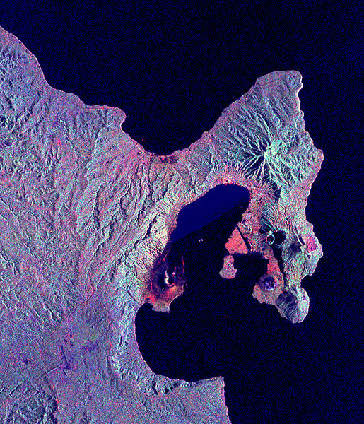
English: Space Radar Image of Rabaul Volcano, New Guinea
Credit NASA JPL http://visibleearth.nasa.gov/view_rec.php?id=434 This is a radar image of the Rabaul volcano on the island of New Britain, Papua New Guinea taken almost a month after its September 19, 1994, eruption that killed five people and covered the town of Rabaul and nearby villages with up to 75 centimeters (30 inches) of ash. More than 53,000 people have been displaced by the eruption. The image was acquired by the Spaceborne Imaging Radar-C/X-band Synthetic Aperture Radar (SIR-C/X-SAR) aboard the space shuttle Endeavour on its 173rd orbit on October 11, 1994. This image is centered at 4.2 degrees south latitude and 152.2 degrees east longitude in the southwest Pacific Ocean. The area shown is approximately 21 kilometers by 25 kilometers (13 miles by 15.5 miles). North is toward the upper right. The colors in this image were obtained using the following radar channels: red represents the L-band (horizontally transmitted and received); green represents the L-band (horizontally transmitted and vertically received); blue represents the C-band (horizontally transmitted and vertically received). |
|||||
| Source | http://visibleearth.nasa.gov/view_rec.php?id=434 | |||||
| Author | NASA/JPL | |||||
| Permission (Reusing this file) |
|

This image or video was catalogued by Jet Propulsion Laboratory of the United States National Aeronautics and Space Administration (NASA) under Photo ID: PIA01767. This tag does not indicate the copyright status of the attached work. A normal copyright tag is still required. See Commons:Licensing. Other languages:
|
Original upload log
The original description page was here. All following user names refer to en.wikipedia.
- 2005-05-17 12:15 SeanMack 853×993× (875239 bytes) {{PD-USGov-NASA}} Space Radar Image of Rabaul Volcano, New Guinea Credit NASA JPL http://visibleearth.nasa.gov/view_rec.php?id=434 This is a radar image of the Rabaul volcano on the island of New Britain, Papua New Guinea taken almost a month after
File history
Click on a date/time to view the file as it appeared at that time.
| Date/Time | Thumbnail | Dimensions | User | Comment | |
|---|---|---|---|---|---|
| current | 13:17, 1 May 2009 | | 853 × 993 (855 KB) | File Upload Bot (Magnus Manske) | {{BotMoveToCommons|en.wikipedia|year={{subst:CURRENTYEAR}}|month={{subst:CURRENTMONTHNAME}}|day={{subst:CURRENTDAY}}}} {{Information |Description={{en|Space Radar Image of Rabaul Volcano, New Guinea Credit NASA JPL http://visibleearth.nasa.gov/view_re |
File usage
The following pages on the English Wikipedia use this file (pages on other projects are not listed):
Global file usage
The following other wikis use this file:
- Usage on br.wikipedia.org
- Usage on fa.wikipedia.org
- Usage on fr.wikipedia.org
- Usage on hu.wikipedia.org
- Usage on id.wikipedia.org
- Usage on it.wikipedia.org
- Usage on ja.wikipedia.org
- Usage on ko.wikipedia.org
- Usage on nl.wikipedia.org
- Usage on ru.wikipedia.org
- Usage on uk.wikipedia.org
- Usage on zh.wikipedia.org