
File:Niagara Falls, Ontario 3.jpg

Original file (1,020 × 680 pixels, file size: 224 KB, MIME type: image/jpeg)
| This is a file from the Wikimedia Commons. Information from its description page there is shown below. Commons is a freely licensed media file repository. You can help. |
Summary
| Description |
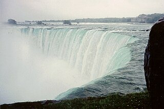
The Niagara Falls are voluminous waterfalls on the Niagara River, straddling the international border between the Canadian province of Ontario and the U.S. state of New York. The falls are 17 miles (27 km) north-northwest of Buffalo, New York and 75 miles (120 km) south-southeast of Toronto, Ontario, between the twin cities of Niagara Falls, Ontario, and Niagara Falls, New York. Niagara Falls is composed of two major sections separated by Goat Island: Horseshoe Falls, the majority of which—two-thirds according to the US Geological Survey—lies on the Canadian side of the border, and American Falls on the American side. The smaller Bridal Veil Falls are also located on the American side, separated from the main falls by Luna Island. Niagara Falls were formed when glaciers receded at the end of the Wisconsin glaciation (the last ice age), and water from the newly formed Great Lakes carved a path through the Niagara Escarpment en route to the Atlantic Ocean. While not exceptionally high, the Niagara Falls are very wide. More than 6 million cubic feet (168,000 m³) of water falls over the crest line every minute in high flow, and almost 4 million cubic feet (110,000 m³) on average. It is the most powerful waterfall in North America. The Niagara Falls are renowned both for their beauty and as a valuable source of hydroelectric power. Managing the balance between recreational, commercial, and industrial uses has been a challenge for the stewards of the falls since the 19th century. Niagara Falls is divided into the Horseshoe Falls and the American Falls. The Horseshoe Falls drop about 173 feet (53 m), the height of the American Falls varies between 70–100 feet (21–30 m) because of the presence of giant boulders at its base. The larger Horseshoe Falls are about 2,600 feet (790 m) wide, while the American Falls are 1,060 feet (320 m) wide. The volume of water approaching the falls during peak flow season may sometimes be as much as 202,000 cubic feet (5,700 m3) per second. Since the flow is a direct function of the Lake Erie water elevation, it typically peaks in late spring or early summer. During the summer months, 100,000 cubic feet (2,800 m3) per second of water actually traverses the Falls, some 90% of which goes over the Horseshoe Falls, while the balance is diverted to hydroelectric facilities. This is accomplished by employing a weir with movable gates upstream from the Horseshoe Falls. The Falls flow is further halved at night, and during the low tourist season in the winter, remains a flat 50,000 cubic feet (1,400 m3) per second. Water diversion is regulated by the 1950 Niagara Treaty and is administered by the International Niagara Board of Control (IJC). Viewpoints on the American shore generally are astride or behind the falls. The falls face directly toward the Canadian shore. en.wikipedia.org/wiki/Niagara_Falls en.wikipedia.org/wiki/Wikipedia:Text_of_Creative_Commons_... |
| Date | |
| Source | Niagara Falls, Ontario 3 |
| Author | Ken Lund from Las Vegas, Nevada, USA |
| Camera location | | View this and other nearby images on: OpenStreetMap |
|---|
Licensing
- You are free:
- to share – to copy, distribute and transmit the work
- to remix – to adapt the work
- Under the following conditions:
- attribution – You must give appropriate credit, provide a link to the license, and indicate if changes were made. You may do so in any reasonable manner, but not in any way that suggests the licensor endorses you or your use.
- share alike – If you remix, transform, or build upon the material, you must distribute your contributions under the same or compatible license as the original.
| This image was originally posted to Flickr by Ken Lund at https://www.flickr.com/photos/75683070@N00/2480300439. It was reviewed on 11 March 2015 by FlickreviewR and was confirmed to be licensed under the terms of the cc-by-sa-2.0. |
File history
Click on a date/time to view the file as it appeared at that time.
| Date/Time | Thumbnail | Dimensions | User | Comment | |
|---|---|---|---|---|---|
| current | 21:52, 11 March 2015 | | 1,020 × 680 (224 KB) | Geo Swan | {{Information |Description=The Niagara Falls are voluminous waterfalls on the Niagara River, straddling the international border between the Canadian province of Ontario and the U.S. state of New York. The falls are 17 miles (27 km) north-northwest of... |