
File:Norfolk County Hall, Martineau Lane - geograph.org.uk - 153348.jpg
No higher resolution available.
Norfolk_County_Hall,_Martineau_Lane_-_geograph.org.uk_-_153348.jpg (640 × 476 pixels, file size: 99 KB, MIME type: image/jpeg)
| This is a file from the Wikimedia Commons. Information from its description page there is shown below. Commons is a freely licensed media file repository. You can help. |
Summary
| Description |
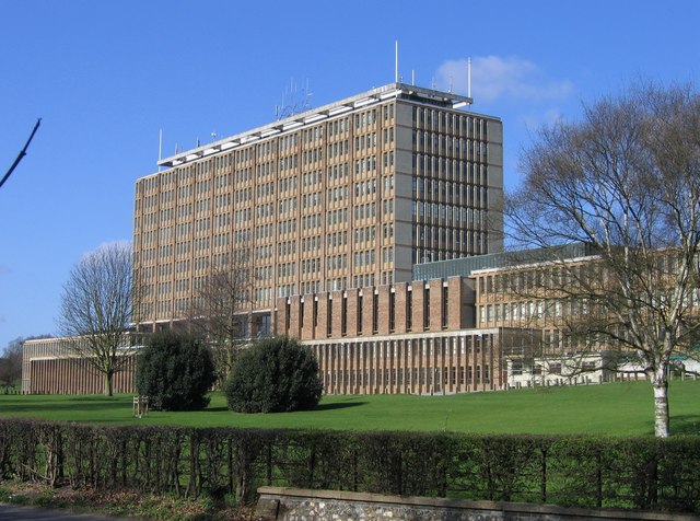
English: Norfolk County Hall, Martineau Lane At the extreme south-west corner of the grid-square stands Norfolk County Hall which was opened on 24th May 1968 by H.M. Queen Elizabeth II. Architect: Reginald Uren. The land on which it was built was once part of the estate of Dr Philip Meadows Martineau (1752-1829), an eminent surgeon who practised for over 50 years at the Norfolk and Norwich Hospital and after whom Martineau Lane was named. http://www.eveningnews24.co.uk/content/Features/DerekJames/StreetNames/extra/040818Martineau.aspx |
| Date | |
| Source | From geograph.org.uk |
| Author | Graham Hardy |
| Attribution (required by the license) | Graham Hardy / Norfolk County Hall, Martineau Lane / |
| Camera location | | View this and other nearby images on: OpenStreetMap |
|---|
_heading:247.00&language=en)
| Object location | | View this and other nearby images on: OpenStreetMap |
|---|
_heading:247.00&language=en)
Licensing

|
This image was taken from the Geograph project collection. See this photograph's page on the Geograph website for the photographer's contact details. The copyright on this image is owned by Graham Hardy and is licensed for reuse under the Creative Commons Attribution-ShareAlike 2.0 license.
|
This file is licensed under the Creative Commons Attribution-Share Alike 2.0 Generic license.
Attribution: Graham Hardy
- You are free:
- to share – to copy, distribute and transmit the work
- to remix – to adapt the work
- Under the following conditions:
- attribution – You must give appropriate credit, provide a link to the license, and indicate if changes were made. You may do so in any reasonable manner, but not in any way that suggests the licensor endorses you or your use.
- share alike – If you remix, transform, or build upon the material, you must distribute your contributions under the same or compatible license as the original.
File history
Click on a date/time to view the file as it appeared at that time.
| Date/Time | Thumbnail | Dimensions | User | Comment | |
|---|---|---|---|---|---|
| current | 09:53, 31 January 2010 | | 640 × 476 (99 KB) | GeographBot | == {{int:filedesc}} == {{Information |description={{en|1=Norfolk County Hall, Martineau Lane At the extreme south-west corner of the grid-square stands Norfolk County Hall which was opened on 24th May 1968 by H.M. Queen Elizabeth II. The land on which it |
File usage
The following pages on the English Wikipedia use this file (pages on other projects are not listed):
Global file usage
The following other wikis use this file:
- Usage on www.wikidata.org