
File:ORD airport map.PNG

Size of this preview: 391 × 600 pixels. Other resolutions: 156 × 240 pixels | 313 × 480 pixels | 807 × 1,238 pixels.
Original file (807 × 1,238 pixels, file size: 247 KB, MIME type: image/png)
| This is a file from the Wikimedia Commons. Information from its description page there is shown below. Commons is a freely licensed media file repository. You can help. |

|
File:ORD Airport Diagram.svg is a vector version of this file. It should be used in place of this PNG file when not inferior.
File:ORD airport map.PNG → File:ORD Airport Diagram.svg
For more information, see Help:SVG. |
 |

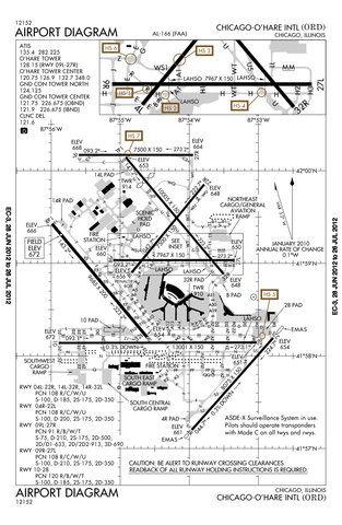
Airport diagram of O'Hare International Airport
This image or file is a work of a Federal Aviation Administration employee, taken or made as part of that person's official duties. As a work of the U.S. federal government, the image is in the public domain in the United States.
|
 |
File history
Click on a date/time to view the file as it appeared at that time.
| Date/Time | Thumbnail | Dimensions | User | Comment | |
|---|---|---|---|---|---|
| current | 22:50, 12 July 2012 | | 807 × 1,238 (247 KB) | Phongn | Update to 28 Jun 2012 version. |
| 01:59, 24 October 2010 |  | 807 × 1,238 (306 KB) | Mareklug | Reverted to version as of 01:52, 24 October 2010 | |
| 01:58, 24 October 2010 |  | 807 × 1,238 (306 KB) | Mareklug | newer, 2nd attempt. | |
| 01:52, 24 October 2010 |  | 807 × 1,238 (306 KB) | Mareklug | newer, larger version (Oct 21, 2010) | |
| 16:40, 7 May 2010 |  | 387 × 594 (98 KB) | Spartan S58 | Showing the shortening of 32L'14R, and changed taxi from P to U. | |
| 23:59, 18 February 2009 |  | 774 × 1,188 (129 KB) | Mahahahaneapneap | Compressed | |
| 03:54, 11 December 2008 |  | 774 × 1,188 (257 KB) | Jalentz | Updated to include opening of runway 9L/27R November 2008 | |
| 19:33, 22 July 2007 |  | 1,570 × 2,285 (305 KB) | Mareklug | Updated (version from 5 July 2007 showing redesignated runway 10/28 which used to be 9R/27L) airport diagram of O'Hare International Airport {{PD-USGov-FAA}} | |
| 21:15, 6 January 2006 |  | 733 × 1,133 (134 KB) | Cmprince | Aiport diagram of O'Hare International Airport {{PD-USGov-FAA}} |
File usage
No pages on the English Wikipedia use this file (pages on other projects are not listed).