
File:Pednvounder beach and Treen Cliff - geograph.org.uk - 229773.jpg
No higher resolution available.
Pednvounder_beach_and_Treen_Cliff_-_geograph.org.uk_-_229773.jpg (640 × 268 pixels, file size: 92 KB, MIME type: image/jpeg)
| This is a file from the Wikimedia Commons. Information from its description page there is shown below. Commons is a freely licensed media file repository. You can help. |
Summary
| Description |
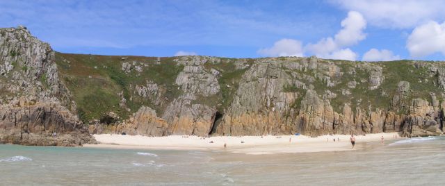
English: Pednvounder beach and Treen Cliff. A panorama of the sandy beach and cliff around low tide - the chasm in the cliff in the centre of the photo is called Daw Zawn (where Zawn means "chasm"). It is possible to walk a long way out from the shore onto the sand bar and only be knee deep in water. Signs on the cliff above the beach warn that swimming off the far side of the sand bar is dangerous due to strong currents. There are a good few people on the beach, but it's never overcrowded as the land route to it involves a long walk with a difficult section of clambering down the rocks. |
| Date | |
| Source | From geograph.org.uk |
| Author | Jim Champion |
| Attribution (required by the license) | Jim Champion / Pednvounder beach and Treen Cliff / |
| Camera location | | View this and other nearby images on: OpenStreetMap |
|---|
_heading:0.00&language=en)
| Object location | | View this and other nearby images on: OpenStreetMap |
|---|
_heading:0.00&language=en)
Licensing

|
This image was taken from the Geograph project collection. See this photograph's page on the Geograph website for the photographer's contact details. The copyright on this image is owned by Jim Champion and is licensed for reuse under the Creative Commons Attribution-ShareAlike 2.0 license.
|
This file is licensed under the Creative Commons Attribution-Share Alike 2.0 Generic license.
Attribution: Jim Champion
- You are free:
- to share – to copy, distribute and transmit the work
- to remix – to adapt the work
- Under the following conditions:
- attribution – You must give appropriate credit, provide a link to the license, and indicate if changes were made. You may do so in any reasonable manner, but not in any way that suggests the licensor endorses you or your use.
- share alike – If you remix, transform, or build upon the material, you must distribute your contributions under the same or compatible license as the original.
File history
Click on a date/time to view the file as it appeared at that time.
| Date/Time | Thumbnail | Dimensions | User | Comment | |
|---|---|---|---|---|---|
| current | 00:03, 1 February 2010 | | 640 × 268 (92 KB) | GeographBot | == {{int:filedesc}} == {{Information |description={{en|1=Pednvounder beach and Treen Cliff. A panorama of the sandy beach and cliff around low tide - the chasm in the cliff in the centre of the photo is called Daw Zawn (where Zawn means "chasm"). It is po |
File usage
The following pages on the English Wikipedia use this file (pages on other projects are not listed):
Global file usage
The following other wikis use this file:
- Usage on www.wikidata.org