
File:Portland aerial tram roads and route.png

Size of this preview: 620 × 600 pixels. Other resolutions: 248 × 240 pixels | 496 × 480 pixels | 794 × 768 pixels | 1,059 × 1,024 pixels | 1,489 × 1,440 pixels.
Original file (1,489 × 1,440 pixels, file size: 406 KB, MIME type: image/png)
| This is a file from the Wikimedia Commons. Information from its description page there is shown below. Commons is a freely licensed media file repository. You can help. |
Legend
Tram route
Driving route (down)
Driving route (up)
Interstate freeway
OHSU campus
Traffic signal
Elevation
700 feet (210 m)
500 feet (150 m) to 700 ft
300 feet (91 m) to 500 ft
200 feet (61 m) to 300 ft
100 feet (30 m) to 200 ft
0 to 100 ft
Leyenda
Ruta del teleférico
Ruta de manejo (descendente)
Ruta de manejo (ascendente)
Carretera interestatal
Campus de OHSU
Señal de tráfico
Elevación
700 feet (210 m)
500 feet (150 m) to 700 feet (210 m)
300 feet (91 m) to 500 feet (150 m)
200 feet (61 m) to 300 feet (91 m)
100 feet (30 m) to 200 feet (61 m)
0 to 100 ft
Summary
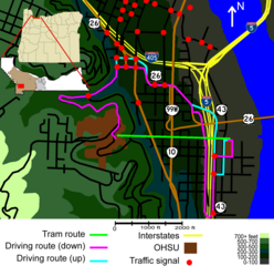
| Description | Diagram of Portland Aerial Tram route contrasted with surface transport routes. This revision cleans up some highway icons, and places Hwy 10 on the correct highway, and attempts to clarify the inset's context. Barbur Blvd north of the intersection with Front Ave. apparently has no highway designation. |
| Date | |
| Source | Own work |
| Author | EncMstr |
Licensing
I, the copyright holder of this work, hereby publish it under the following licenses:

|
Permission is granted to copy, distribute and/or modify this document under the terms of the GNU Free Documentation License, Version 1.2 or any later version published by the Free Software Foundation; with no Invariant Sections, no Front-Cover Texts, and no Back-Cover Texts. A copy of the license is included in the section entitled GNU Free Documentation License. |
This file is licensed under the Creative Commons Attribution-Share Alike 3.0 Unported, 2.5 Generic, 2.0 Generic and 1.0 Generic license.
- You are free:
- to share – to copy, distribute and transmit the work
- to remix – to adapt the work
- Under the following conditions:
- attribution – You must give appropriate credit, provide a link to the license, and indicate if changes were made. You may do so in any reasonable manner, but not in any way that suggests the licensor endorses you or your use.
- share alike – If you remix, transform, or build upon the material, you must distribute your contributions under the same or compatible license as the original.
You may select the license of your choice.
File history
Click on a date/time to view the file as it appeared at that time.
| Date/Time | Thumbnail | Dimensions | User | Comment | |
|---|---|---|---|---|---|
| current | 15:06, 1 November 2007 | | 1,489 × 1,440 (406 KB) | EncMstr | == Summary == {{Information |Description=Diagram of Portland Aerial Tram route contrasted with surface transport routes. This revision cleans up some highway icons, and places Hwy 10 on the correct highway. Barbur Blvd north o |
| 07:06, 30 October 2007 |  | 1,489 × 1,440 (375 KB) | EncMstr | == Summary == {{Information |Description=Diagram of Portland Aerial Tram route compared to surface transport. Includes commons works [[:Image:Multnomah County Oregon Incorporated and Unincorporated areas Portland Highlighted.sv | |
| 08:13, 26 October 2007 |  | 1,489 × 1,440 (299 KB) | EncMstr | == Summary == {{Information |Description=Diagram of Portland Aerial Tram route compared to surface transport. Green is the tram's route, brown is OHSU campuses, magenta is the nominal fastest driving route downhill, cyan is the | |
| 08:48, 25 October 2007 |  | 1,489 × 1,152 (116 KB) | EncMstr | == Summary == {{Information |Description=Diagram of Portland Aerial Tram route compared to surface transport. Green is the tram's route, brown is OHSU campuses, magenta is the norminal fastest driving route downhill, cyan is th | |
| 08:31, 25 October 2007 |  | 1,489 × 1,152 (107 KB) | EncMstr | {{Information |Description=Diagram of w:Portland Aerial Tram route compared to surface transport. Green is the tram's route, brown is OHSU campuses, magenta is the norminal fastest driving route downhill, cyan is the driving route uphill where it de |
File usage
The following pages on the English Wikipedia use this file (pages on other projects are not listed):
Global file usage
The following other wikis use this file:
- Usage on es.wikipedia.org
- Usage on hu.wikipedia.org
- Usage on pt.wikipedia.org