
File:Shinkansen map 20101204 en.png
Size of this preview: 581 × 600 pixels. Other resolutions: 232 × 240 pixels | 465 × 480 pixels | 744 × 768 pixels | 992 × 1,024 pixels | 1,984 × 2,048 pixels | 3,100 × 3,200 pixels.
Original file (3,100 × 3,200 pixels, file size: 359 KB, MIME type: image/png)
| This is a file from the Wikimedia Commons. Information from its description page there is shown below. Commons is a freely licensed media file repository. You can help. |
Summary
| Description |
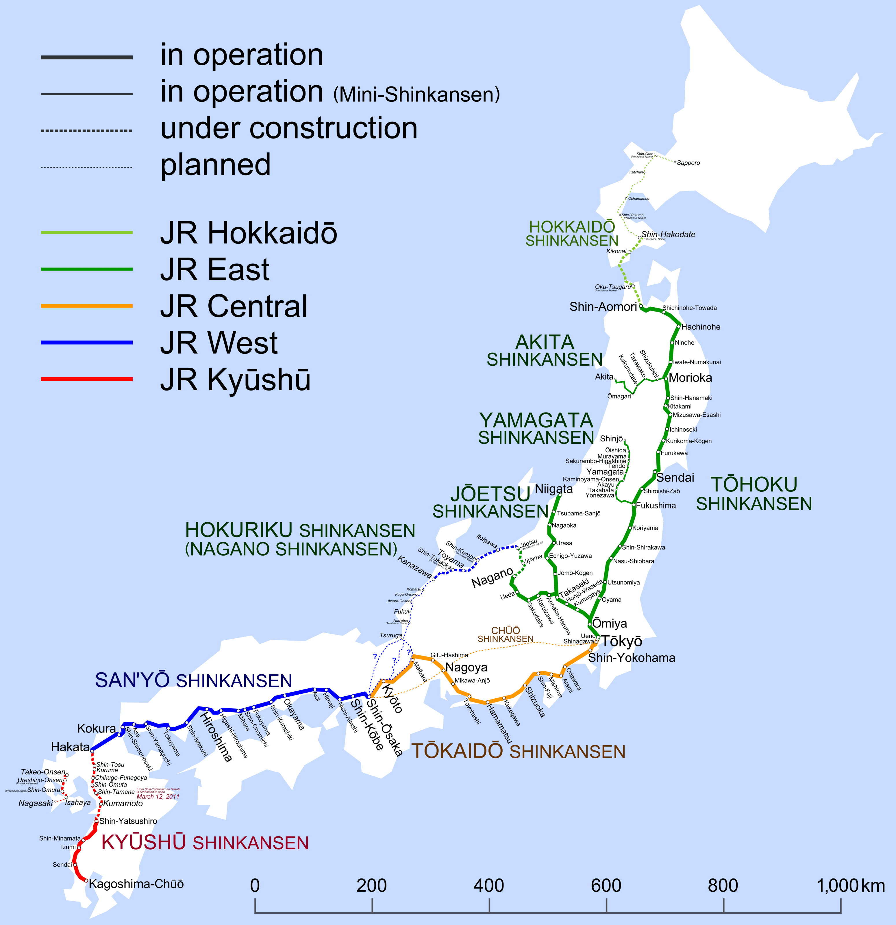
English: Map of Shinkansen network. (2010-12-04 – 2011-03-11) |
||||||||||||||||||||||||||||||||
| Date | |||||||||||||||||||||||||||||||||
| Source | Own work | ||||||||||||||||||||||||||||||||
| Author | Hisagi (氷鷺) | ||||||||||||||||||||||||||||||||
| Other versions |
|
Licensing
I, the copyright holder of this work, hereby publish it under the following licenses:
This file is licensed under the Creative Commons Attribution-Share Alike 3.0 Unported license.
- You are free:
- to share – to copy, distribute and transmit the work
- to remix – to adapt the work
- Under the following conditions:
- attribution – You must give appropriate credit, provide a link to the license, and indicate if changes were made. You may do so in any reasonable manner, but not in any way that suggests the licensor endorses you or your use.
- share alike – If you remix, transform, or build upon the material, you must distribute your contributions under the same or compatible license as the original.

|
Permission is granted to copy, distribute and/or modify this document under the terms of the GNU Free Documentation License, Version 1.2 or any later version published by the Free Software Foundation; with no Invariant Sections, no Front-Cover Texts, and no Back-Cover Texts. A copy of the license is included in the section entitled GNU Free Documentation License. |
You may select the license of your choice.
File history
Click on a date/time to view the file as it appeared at that time.
| Date/Time | Thumbnail | Dimensions | User | Comment | |
|---|---|---|---|---|---|
| current | 23:19, 7 March 2011 | | 3,100 × 3,200 (359 KB) | Hisagi | Ōyama→Oyama |
| 04:43, 5 March 2011 |  | 3,100 × 3,200 (381 KB) | Hisagi | 福井と南越の逆転を訂正 | |
| 15:15, 3 December 2010 |  | 3,100 × 3,200 (326 KB) | Hisagi | {{Information |Description={{en|1=Map of Shinkansen network.<ul><li>Bold solid lines are Shinkansen lines in operation.</li><li>Thin solid lines are Mini-Shinkansen lines in operation.</li><li>Bold broken lines are under construction |
File usage
No pages on the English Wikipedia use this file (pages on other projects are not listed).