
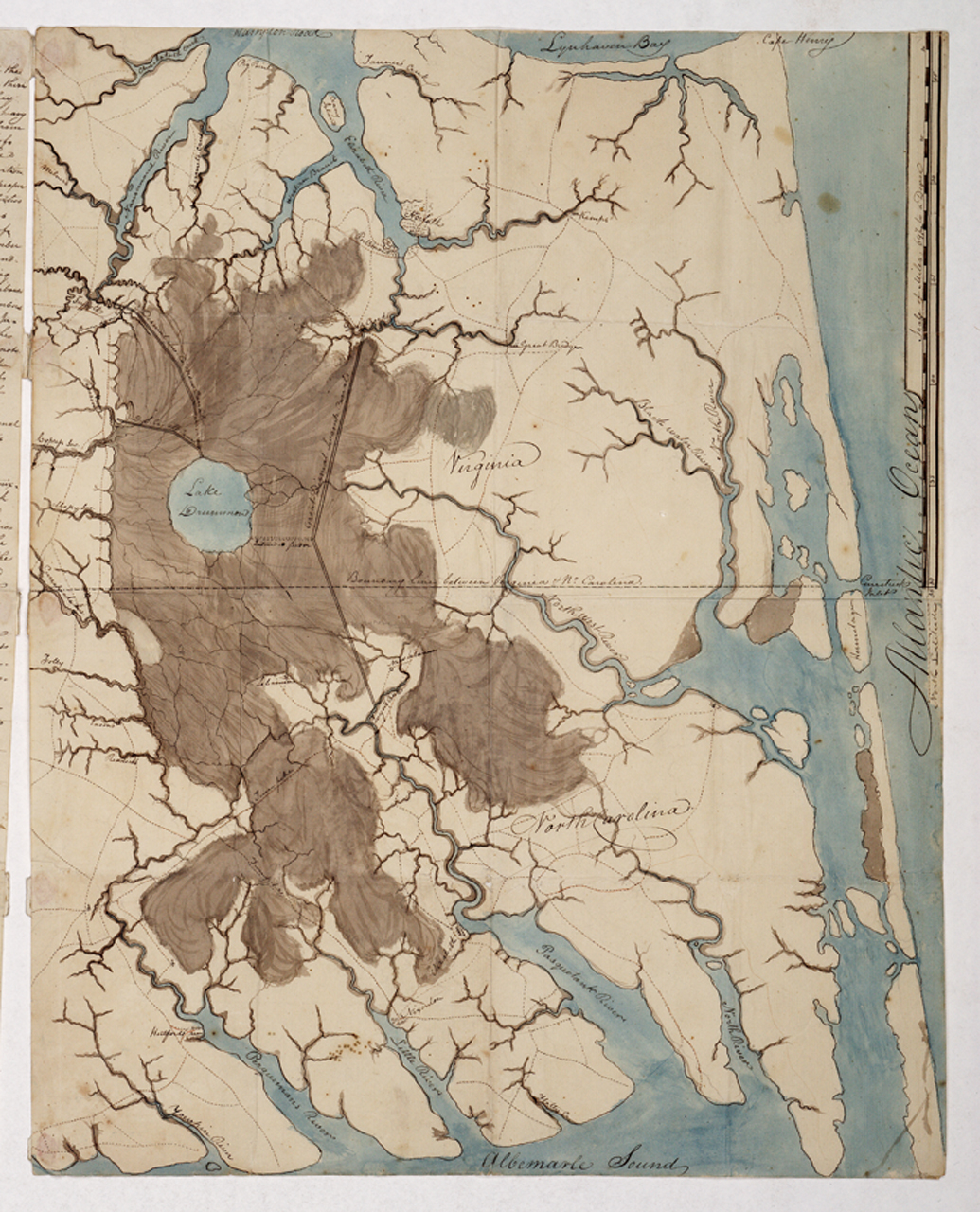
File:Sketch map of the Great Dismal Swamp RMG K1082.jpg
Original file (1,035 × 1,280 pixels, file size: 1.11 MB, MIME type: image/jpeg)
| This is a file from the Wikimedia Commons. Information from its description page there is shown below. Commons is a freely licensed media file repository. You can help. |
Summary
| Author |
Anonymous |
| Description |
English: [Sketch map of the Great Dismal Swamp]Single sheet. Col. ms. Scale: 1:200 000 (bar). Cartographic Note: Scale in miles. Additional Places: Virginia, North Carolina. Contents Note: Shows the Great Dismal Swamp Canal, linking Chesapeake Bay in the north with Albemarle Sound in the south.
The sketch is accompanied by a page of text, 'Questions and answers on the Swamp. Answers to Col. Hamilton's questions respecting the Great Dismal Swamp', concerning its length and breadth, the growth of timber, extent of cultivation, canal cutting, seasonal factors and whether any animals are peculiar to the Swamp. |
| Date | 1807 |
| Dimensions | 51 x 40.5cm. |
| Notes | For an analysis of the bias towards geographical coverage when looking at the contents of the collection see tables from the printed (complete) biography of Grenville. This is kept with the red binders as part of the Grenville collection binder (in SOG). |
| Source/Photographer | http://collections.rmg.co.uk/collections/objects/542115 |
| Permission (Reusing this file) |
The original artefact or artwork has been assessed as public domain by age, and faithful reproductions of the two dimensional work are also public domain. No permission is required for reuse for any purpose. The text of this image record has been derived from the Royal Museums Greenwich catalogue and image metadata. Individual data and facts such as date, author and title are not copyrightable, but reuse of longer descriptive text from the catalogue may not be considered fair use. Reuse of the text must be attributed to the "National Maritime Museum, Greenwich, London" and a Creative Commons CC-BY-NC-SA-3.0 license may apply if not rewritten. Refer to Royal Museums Greenwich copyright. |
| Identifier | GGCC: 293:41 id number: GREN78/1 |
| Collection | Charts and maps |
Licensing
|
This is a faithful photographic reproduction of a two-dimensional, public domain work of art. The work of art itself is in the public domain for the following reason:
The official position taken by the Wikimedia Foundation is that "faithful reproductions of two-dimensional public domain works of art are public domain".
This photographic reproduction is therefore also considered to be in the public domain in the United States. In other jurisdictions, re-use of this content may be restricted; see Reuse of PD-Art photographs for details. | ||||
File history
Click on a date/time to view the file as it appeared at that time.
| Date/Time | Thumbnail | Dimensions | User | Comment | |
|---|---|---|---|---|---|
| current | 10:58, 1 September 2017 | | 1,035 × 1,280 (1.11 MB) | Fæ | Royal Museums Greenwich Charts and maps, http://collections.rmg.co.uk/collections/objects/542115 |