
File:St John the Baptist - geograph.org.uk - 1221508.jpg
No higher resolution available.
St_John_the_Baptist_-_geograph.org.uk_-_1221508.jpg (640 × 480 pixels, file size: 70 KB, MIME type: image/jpeg)
| This is a file from the Wikimedia Commons. Information from its description page there is shown below. Commons is a freely licensed media file repository. You can help. |
Summary
| Description |
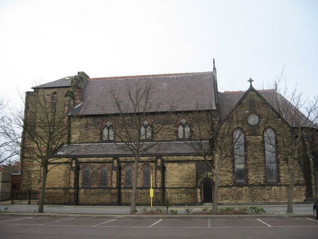
English: St John the Baptist St John the Baptist in Earlestown is a large church but looks somewhat unbalanced probably due to the fact that the original plans had included a clock tower which had to be curtailed due to lack of funding. On August 4, 1875,the foundation stone was laid by Mrs. W J. Legh, wife of the Lord of the Manor, who had donated the land in Market Street. The new Church was consecrated on January 6, 1879. |
| Date | |
| Source | From geograph.org.uk |
| Author | Sue Adair |
| Attribution (required by the license) | Sue Adair / St John the Baptist / |
| Camera location | | View this and other nearby images on: OpenStreetMap |
|---|
_heading:45.00&language=en)
| Object location | | View this and other nearby images on: OpenStreetMap |
|---|
_heading:45.00&language=en)
Licensing

|
This image was taken from the Geograph project collection. See this photograph's page on the Geograph website for the photographer's contact details. The copyright on this image is owned by Sue Adair and is licensed for reuse under the Creative Commons Attribution-ShareAlike 2.0 license.
|
This file is licensed under the Creative Commons Attribution-Share Alike 2.0 Generic license.
Attribution: Sue Adair
- You are free:
- to share – to copy, distribute and transmit the work
- to remix – to adapt the work
- Under the following conditions:
- attribution – You must give appropriate credit, provide a link to the license, and indicate if changes were made. You may do so in any reasonable manner, but not in any way that suggests the licensor endorses you or your use.
- share alike – If you remix, transform, or build upon the material, you must distribute your contributions under the same or compatible license as the original.
File history
Click on a date/time to view the file as it appeared at that time.
| Date/Time | Thumbnail | Dimensions | User | Comment | |
|---|---|---|---|---|---|
| current | 10:59, 26 February 2011 | | 640 × 480 (70 KB) | GeographBot | == {{int:filedesc}} == {{Information |description={{en|1=St John the Baptist St John the Baptist in Earlestown is a large church but looks somewhat unbalanced probably due to the fact that the original plans had included a clock tower which had to be curt |
File usage
The following pages on the English Wikipedia use this file (pages on other projects are not listed):