
File:Swim Coots Drainage Mill - geograph.org.uk - 577959.jpg
No higher resolution available.
Swim_Coots_Drainage_Mill_-_geograph.org.uk_-_577959.jpg (640 × 480 pixels, file size: 87 KB, MIME type: image/jpeg)
| This is a file from the Wikimedia Commons. Information from its description page there is shown below. Commons is a freely licensed media file repository. You can help. |
Summary
| Description |
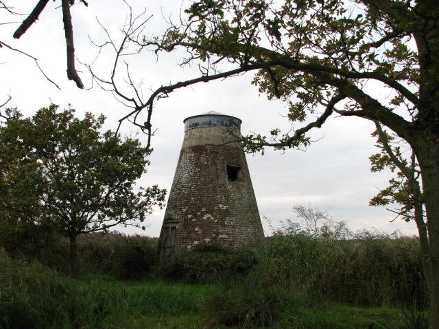
English: Swim Coots Drainage Mill Swim Coots Drainage Mill is located in the Hickling Broad National Nature Reserve. The track leading to this mill is private, but permission for access will be granted when sought. This mill was built as a drainage mill, but it used to have a single small pair of stones that had been incorporated within the structure to grind animal feed. The mill stood by a dyke on the shore of Hickling Broad at the end of a long track, through marshy reed beds, and it once had a Norfolk boat shaped cap, patent sails and a fantail.
For more detailed information see http://www.norfolkmills.co.uk/WindmillsD/catfield-swim-coots-drainage.html Hickling Broad with its 500 acres of open water is the largest of the broads and Hickling Broad National Nature Reserve is an internationally important wetland habitat where endangered species such as the marsh harrier, bittern and swallowtail butterfly, as well as summer visitors like the spoonbill, are to be found in its grassland and marshes. The nature reserve can be accessed via a number of walking trails, some with hides for bird watchers. The Weavers Way also runs through the reserve. |
| Date | |
| Source | From geograph.org.uk |
| Author | Evelyn Simak |
| Attribution (required by the license) | Evelyn Simak / Swim Coots Drainage Mill / |
| Camera location | | View this and other nearby images on: OpenStreetMap |
|---|
_heading:315.00&language=en)
| Object location | | View this and other nearby images on: OpenStreetMap |
|---|
_heading:315.00&language=en)
Licensing

|
This image was taken from the Geograph project collection. See this photograph's page on the Geograph website for the photographer's contact details. The copyright on this image is owned by Evelyn Simak and is licensed for reuse under the Creative Commons Attribution-ShareAlike 2.0 license.
|
This file is licensed under the Creative Commons Attribution-Share Alike 2.0 Generic license.
Attribution: Evelyn Simak
- You are free:
- to share – to copy, distribute and transmit the work
- to remix – to adapt the work
- Under the following conditions:
- attribution – You must give appropriate credit, provide a link to the license, and indicate if changes were made. You may do so in any reasonable manner, but not in any way that suggests the licensor endorses you or your use.
- share alike – If you remix, transform, or build upon the material, you must distribute your contributions under the same or compatible license as the original.
File history
Click on a date/time to view the file as it appeared at that time.
| Date/Time | Thumbnail | Dimensions | User | Comment | |
|---|---|---|---|---|---|
| current | 11:34, 6 February 2011 | | 640 × 480 (87 KB) | GeographBot | == {{int:filedesc}} == {{Information |description={{en|1=Swim Coots Drainage Mill Swim Coots Drainage Mill is located in the Hickling Broad National Nature Reserve. The track leading to this mill is private, but permission for access will be granted when |
File usage
The following pages on the English Wikipedia use this file (pages on other projects are not listed):
Global file usage
The following other wikis use this file:
- Usage on www.wikidata.org