
File:Tectonic plates boundaries detailed-en.svg

Size of this PNG preview of this SVG file: 800 × 402 pixels. Other resolutions: 320 × 161 pixels | 640 × 322 pixels | 1,024 × 515 pixels | 1,280 × 643 pixels | 2,560 × 1,286 pixels | 4,898 × 2,461 pixels.
Original file (SVG file, nominally 4,898 × 2,461 pixels, file size: 1.23 MB)
| This is a file from the Wikimedia Commons. Information from its description page there is shown below. Commons is a freely licensed media file repository. You can help. |
Summary
| Description |
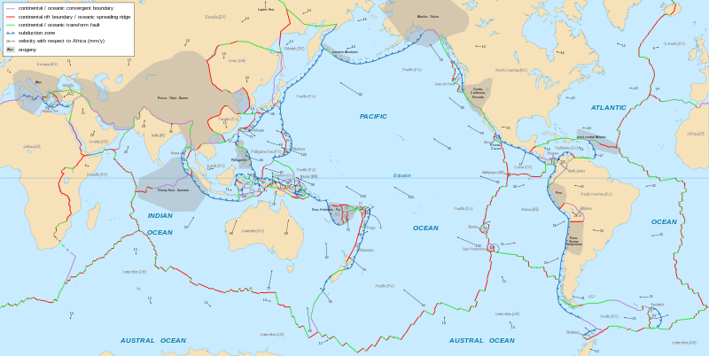
English: Detailed world map in English showing the tectonic plates with their movement vectors
Français : Carte détaillée en anglais des plaques tectoniques avec leurs vecteurs de déplacement
Español: Mapa detallado en inglés que muestra las placas tectónicas con sus vectores de movimiento |
||
| Date | 2006-10, updated 2015-09 | ||
| Source |
|
||
| Author | Eric Gaba (Sting - fr:Sting) | ||
| Permission (Reusing this file) |
|
||
| Other versions |
Derivative works of this file: Philippine Sea Plate br.JPG
|


.svg)


|
This SVG file contains embedded text that can be translated into your language, using any capable SVG editor, text editor or the SVG Translate tool. For more information see: About translating SVG files. |
Licensing
I, the copyright holder of this work, hereby publish it under the following license:
This file is licensed under the Creative Commons Attribution-Share Alike 2.5 Generic license.
- You are free:
- to share – to copy, distribute and transmit the work
- to remix – to adapt the work
- Under the following conditions:
- attribution – You must give appropriate credit, provide a link to the license, and indicate if changes were made. You may do so in any reasonable manner, but not in any way that suggests the licensor endorses you or your use.
- share alike – If you remix, transform, or build upon the material, you must distribute your contributions under the same or compatible license as the original.
File history
Click on a date/time to view the file as it appeared at that time.
| Date/Time | Thumbnail | Dimensions | User | Comment | |
|---|---|---|---|---|---|
| current | 16:29, 9 February 2023 | | 4,898 × 2,461 (1.23 MB) | Roxy | File uploaded using svgtranslate tool (https://svgtranslate.toolforge.org/). Added translation for tr. |
| 21:48, 25 January 2018 |  | 4,898 × 2,461 (1.14 MB) | Sting | Corrections on subduction directions | |
| 22:11, 15 January 2018 |  | 4,898 × 2,461 (1.14 MB) | Sting | Panama plate name | |
| 18:08, 6 September 2015 |  | 4,898 × 2,461 (1.14 MB) | Sting | Equator line correction | |
| 18:04, 6 September 2015 |  | 4,898 × 2,461 (1.14 MB) | Sting | Frame removed | |
| 17:38, 6 September 2015 |  | 4,898 × 2,461 (1.14 MB) | Sting | Shetland microplate direction added | |
| 17:28, 6 September 2015 |  | 4,898 × 2,461 (1.14 MB) | Sting | New background map using NGDC WCL data | |
| 07:50, 10 May 2015 |  | 4,898 × 2,472 (843 KB) | 白布飘扬 | Shetland microplate: base on the original source, the movement speed is unclear but the direction is there. | |
| 17:21, 1 October 2013 |  | 4,898 × 2,472 (841 KB) | Sting | Shetland microplate: movement undefined => deleting the arrow | |
| 15:52, 6 September 2012 |  | 4,898 × 2,472 (842 KB) | McZusatz | typo corr. |
File usage
The following pages on the English Wikipedia use this file (pages on other projects are not listed):
Global file usage
The following other wikis use this file:
- Usage on ar.wikipedia.org
- الصفائح التكتونية
- صفيحة المحيط الهادي
- صفيحة أمريكا الشمالية
- جزر غالاباغوس
- الصفيحة العربية
- صفيحة أوراسية
- الصفيحة الإفريقية
- حيد المحيط الهادئ والقطب الجنوبي
- حيد جنوب غرب المحيط الهندي
- حيد وسط المحيط الهندي
- ارتفاع شرق المحيط الهادئ
- حيد جاكل
- حيد وسط المحيط الأطلسي
- صفيحة خوان دو فوكا
- صفيحة هندية
- صفيحة هندية أسترالية
- صفيحة أمريكا الجنوبية
- صفيحة تونجا
- صفيحة نازكا
- قالب:الصفائح التكتونية
- صفيحة الفلبين
- صفيحة الكاريبي
- الصفيحة القطبية الجنوبية
- الصفيحة الصومالية
- صفيحة كوكوس
- نيكولاي كنيبوفيتش
- قائمة الصفائح التكتونية
- النقطة الساخنة غالاباغوس
- الصفيحة الأناضولية
- صفيحة لاسا
- مستخدم:Nehaoua/ملعب13
- القوس القبرصي
- القوس الهيليني
- الصفيحة الأسترالية
- صفيحة بورما
- صفيحة فيكتوريا الصغيرة
- الخندق الهيليني
- Usage on az.wikipedia.org
View more global usage of this file.