
File:UK high speed rail map.png
Size of this preview: 343 × 600 pixels. Other resolutions: 137 × 240 pixels | 274 × 480 pixels | 439 × 768 pixels | 586 × 1,024 pixels | 2,000 × 3,496 pixels.
Original file (2,000 × 3,496 pixels, file size: 570 KB, MIME type: image/png)
| This is a file from the Wikimedia Commons. Information from its description page there is shown below. Commons is a freely licensed media file repository. You can help. |
Summary
| Description |
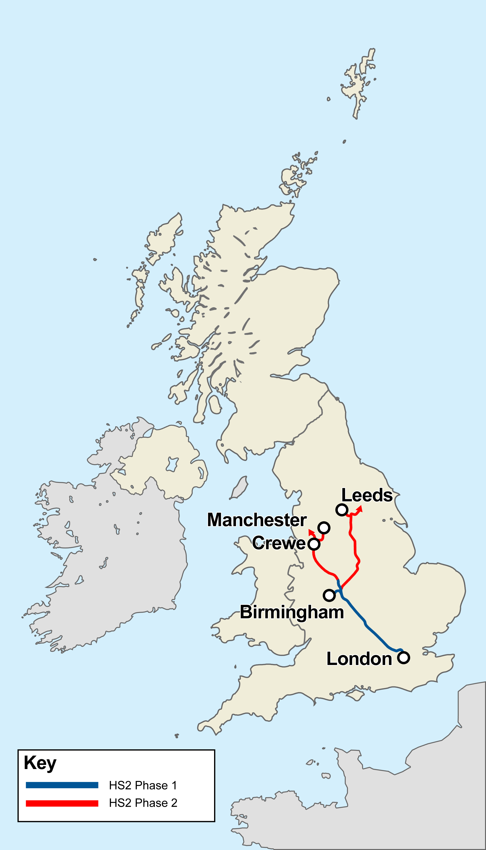
English: Outline map of new high-speed rail lines in the UK showing the existing LGV/Channel Tunnel and High Speed 1 to London, along with the the planned High Speed 2 lines as announced by the UK Department for Transport:
|
||
| Date | |||
| Source | Own work | ||
| Author | Cnbrb | ||
| Other versions |
|

Proposals subject to change following the formation of a new government in May 2010
Licensing
I, the copyright holder of this work, hereby publish it under the following licenses:
This file is licensed under the Creative Commons Attribution-Share Alike 3.0 Unported license.
- You are free:
- to share – to copy, distribute and transmit the work
- to remix – to adapt the work
- Under the following conditions:
- attribution – You must give appropriate credit, provide a link to the license, and indicate if changes were made. You may do so in any reasonable manner, but not in any way that suggests the licensor endorses you or your use.
- share alike – If you remix, transform, or build upon the material, you must distribute your contributions under the same or compatible license as the original.

|
Permission is granted to copy, distribute and/or modify this document under the terms of the GNU Free Documentation License, Version 1.2 or any later version published by the Free Software Foundation; with no Invariant Sections, no Front-Cover Texts, and no Back-Cover Texts. A copy of the license is included in the section entitled GNU Free Documentation License. |
You may select the license of your choice.
File history
Click on a date/time to view the file as it appeared at that time.
| Date/Time | Thumbnail | Dimensions | User | Comment | |
|---|---|---|---|---|---|
| current | 13:43, 3 May 2019 | | 2,000 × 3,496 (570 KB) | Cnbrb | remove sheffield, add crewe |
| 19:10, 8 November 2017 |  | 2,000 × 3,496 (574 KB) | Cnbrb | minor discrepancy with line colour! | |
| 19:09, 8 November 2017 |  | 2,000 × 3,496 (574 KB) | Cnbrb | Removed other lines as requested by user discussion on English Wikipedia talk page. | |
| 01:14, 20 February 2014 |  | 2,000 × 3,496 (380 KB) | Kopiersperre | optipng | |
| 11:44, 17 March 2013 |  | 2,000 × 3,496 (643 KB) | Cnbrb | adjust outline for future phases (Scotland) | |
| 16:25, 30 January 2013 |  | 2,000 × 3,496 (642 KB) | Cnbrb | shaded Glasgow-Edin darker as it is proposed separately | |
| 14:02, 30 January 2013 |  | 2,000 × 3,496 (642 KB) | Cnbrb | Isle of Man shading was politically inaccurate | |
| 13:49, 30 January 2013 |  | 2,000 × 3,496 (642 KB) | Cnbrb | updated to reflect [http://www.bbc.co.uk/news/uk-21221828 2013 announcements about phase 2] (Manchester/Leeds). Scottish routes are based on [http://www.transportscotland.gov.uk/strategy-and-research/publications-and-consultations/j202923-03.htm projec... | |
| 23:34, 11 January 2012 |  | 500 × 874 (160 KB) | Cnbrb | tidy outlines again | |
| 23:32, 11 January 2012 |  | 500 × 874 (160 KB) | Cnbrb | tidy outlines |
File usage
No pages on the English Wikipedia use this file (pages on other projects are not listed).
Global file usage
The following other wikis use this file:
- Usage on cs.wikipedia.org
- Usage on hu.wikipedia.org
- Usage on ja.wikipedia.org
- Usage on uk.wikipedia.org
- Usage on www.wikidata.org
- Usage on zh.wikipedia.org