
File:Waterloo Campaign map-alt3.svg

Size of this PNG preview of this SVG file: 527 × 599 pixels. Other resolutions: 211 × 240 pixels | 422 × 480 pixels | 675 × 768 pixels | 900 × 1,024 pixels | 1,801 × 2,048 pixels | 1,500 × 1,706 pixels.
Original file (SVG file, nominally 1,500 × 1,706 pixels, file size: 1.04 MB)
| This is a file from the Wikimedia Commons. Information from its description page there is shown below. Commons is a freely licensed media file repository. You can help. |
| This is a featured picture, which means that members of the community have identified it as one of the finest images on the English Wikipedia, adding significantly to its accompanying article. If you have a different image of similar quality, be sure to upload it using the proper free license tag, add it to a relevant article, and nominate it. |
| This image was selected as picture of the day on the English Wikipedia for June 15, 2008. |
|
| Camera location | | View this and other nearby images on: OpenStreetMap |
|---|
Summary
| Description |
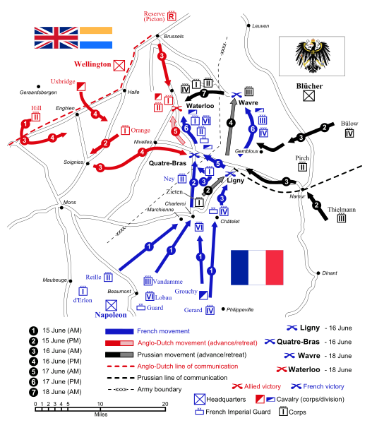
English: Map of force movements and major engagements during the Waterloo Campaign, June 15-18, 1815. Català: Mapa dels moviments i dels principals enfrontaments durant la Campanya de Waterloo, 15-18 de juny, 1815.
|
||||||||
| Date | |||||||||
| Source |
Own work (Original text: Self-made. Vectorized from raster image |
||||||||
| Author | Ipankonin | ||||||||
| Permission (Reusing this file) |
I, the copyright holder of this work, hereby publish it under the following licenses:
This file is licensed under the Creative Commons Attribution-Share Alike 2.5 Generic, 2.0 Generic and 1.0 Generic license.
You may select the license of your choice. |
||||||||
| Other versions |
   |
||||||||
| SVG development | |||||||||
| SVG development |
|


File history
Click on a date/time to view the file as it appeared at that time.
| Date/Time | Thumbnail | Dimensions | User | Comment | |
|---|---|---|---|---|---|
| current | 10:09, 24 January 2008 | | 1,500 × 1,706 (1.04 MB) | Ipankonin | Reverted to version as of 08:39, 2 January 2008 |
| 10:07, 24 January 2008 |  | 1,500 × 1,706 (1.04 MB) | Ipankonin | ||
| 10:05, 24 January 2008 |  | 1,500 × 1,706 (1.04 MB) | Ipankonin | change background from an object to a document property | |
| 08:39, 2 January 2008 |  | 1,500 × 1,706 (1.04 MB) | Ipankonin | slightly smaller nominal size | |
| 08:18, 2 January 2008 |  | 2,000 × 2,275 (1.05 MB) | Ipankonin | larger nominal size | |
| 23:59, 1 January 2008 |  | 800 × 910 (1.05 MB) | Ipankonin | {{Inkscape}} {{Information |Description= {{en|Map of force movements and major engagements during the Waterloo Campaign, June 15-18, 1815.}} |Source=Self-made. Vectorized from raster image 100px Flags from [[Image:Fl |
File usage
The following pages on the English Wikipedia use this file (pages on other projects are not listed):
- Battle of Ligny
- Battle of Quatre Bras
- Battle of Waterloo
- Battle of Wavre
- British Army during the Napoleonic Wars
- Hundred Days
- James Graham (British Army soldier)
- Jean Victor de Constant Rebecque
- Military strategy
- Napoleonic Wars
- Napoleonic weaponry and warfare
- Order of battle of the Waterloo campaign
- Waterloo campaign
- Waterloo campaign: Quatre Bras to Waterloo
- Talk:Battle of Waterloo/Archive 9
- User:NJInce/sandbox
- User talk:Gsl
- User talk:Ipankonin
- User talk:Ipankonin/Archive 3
- Wikipedia:Featured picture candidates/January-2008
- Wikipedia:Featured picture candidates/Waterloo Campaign Map
- Wikipedia:Featured pictures/Diagrams, drawings, and maps/Maps
- Wikipedia:Featured pictures thumbs/09
- Wikipedia:Picture of the day/June 2008
- Wikipedia:WikiProject Military history/Showcase
- Wikipedia:WikiProject Military history/Showcase/FP
- Wikipedia:WikiProject United States/Featured pictures
- Wikipedia:WikiProject United States/Quality content
- Wikipedia:WikiProject United States/Recognized content
- Wikipedia:Wikipedia Signpost/2008-01-07/Features and admins
- Wikipedia:Wikipedia Signpost/2008-01-07/SPV
- Wikipedia:Wikipedia Signpost/Single/2008-01-07
- Template:POTD/2008-06-15
- Portal:Maps/Selected picture
- Portal:Maps/Selected picture/33
- Portal:Netherlands/Selected picture
Global file usage
The following other wikis use this file:
- Usage on azb.wikipedia.org
- Usage on ca.wikipedia.org
- Usage on cs.wikipedia.org
- Usage on da.wikipedia.org
- Usage on de.wikipedia.org
- Usage on el.wikipedia.org
- Usage on es.wikipedia.org
- Usage on et.wikipedia.org
- Usage on eu.wikipedia.org
- Usage on fa.wikipedia.org
- Usage on fr.wikipedia.org
- Usage on hy.wikipedia.org
- Usage on id.wikipedia.org
- Usage on io.wikipedia.org
- Usage on it.wikipedia.org
- Usage on ja.wikipedia.org
- Usage on ka.wikipedia.org
- Usage on kn.wikipedia.org
- Usage on lt.wikipedia.org
- Usage on ml.wikipedia.org
- Usage on ms.wikipedia.org
- Usage on mt.wikipedia.org
- Usage on nds.wikipedia.org
- Usage on nl.wikipedia.org
- Usage on nn.wikipedia.org
- Usage on no.wikipedia.org
- Usage on pa.wikipedia.org
- Usage on pl.wikipedia.org
- Usage on pnb.wikipedia.org
- Usage on pt.wikipedia.org
- Usage on sk.wikipedia.org
- Usage on sq.wikipedia.org
- Usage on th.wikipedia.org
- Usage on tr.wikipedia.org
View more global usage of this file.