Fort Churchill and Sand Springs Toll Road
Appearance
Fort Churchill and Sand Springs Toll Road | |
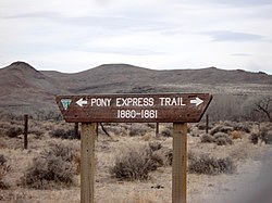
 Pony Express Trail sign on Fort Churchill Road | |
| NRHP reference No. | 97001383 |
|---|---|
| Added to NRHP | November 24, 1997 |
Fort Churchill and Sand Springs Toll Road was opened in 1866.
A segment of the toll road within Churchill County, Nevada is listed on the National Register of Historic Places on November 24, 1974. This segment allowed a team of 18 mules to pull three heavily laden freight wagons across a mountain. One end of the road was located at Fort Churchill.
Running between Dayton and the former Sand Springs Pony Express Station along US 50 east of Fallon, the route provided a reliable supply route from the Comstock, Carson City and California to the Reese River Mining District centered in Austin.[1]
Sources
References
- ^ "Nevada Department of Museums, Library and Arts". Archived from the original on 2006-09-23. Retrieved 2006-07-19.
