
Fort Énet
| Fort Énet | |
|---|---|
| Between the Île-d'Aix and Fouras in the Pertuis d'Antioche straits, on the west coast of France. | |
 Fort Énet at low tide. | |
 Fort Énet | |
| Type | Fortress |
| Site information | |
| Controlled by | |
Fort Énet is a fortification in the Pertuis d'Antioche in Charente-Maritime, France. It is located on the "Pointe de la Fumée", the roadway extending from the city of Fouras, between Fouras and Île-d'Aix, and can be accessed from there at low tide.
Fort Énet formed a line of fortification with Fort Boyard and Fort de la Rade on Île-d'Aix, designed to protect the arsenal of Rochefort from Royal Navy incursions.[1] The building of the fort was started in 1810 by Napoleon I, following the devastating 1809 Battle of the Basque Roads.
The Fort can be reached on foot at low tide, and can be visited.
Fort Enet is listed as a Monument Historique. It is indexed in the Base Mérimée, a database of the French architectural patrimony maintained by the French Ministry of Culture, under the reference PA00132807.
-
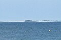 Fort Énet from Ile d'Oléron.
 -
 Fort Enet at low tide, with Fort Boyard (left) and Fort de la Rade on Île-d'Aix (right) in the background.
 -
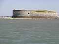 Fort Enet from the bay of Île-d'Aix.
 -
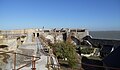 Internal structure of Fort Enet.
 -
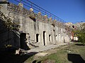 Inside Fort Enet.
 -
 Fort Enet gun, with Ile d'Aix in the background.

.jpg)


